


| Oliver's Cornwall |
|
Walking
Trail from
Boscastle to Looe |
|
|
|
|
|
|
|
|
Text and images should align. To view this page at its best, adjust your zoom so that the page uses full screen width
ON THIS PAGE
| Boscastle to Davidstow Moor | Davidstow Moor to Jamaica Inn | Jamaica Inn to Dobwalls | Dobwalls to Looe |
CORNWALL REVIEWS
INDEX and SITE CONTENTS
|
|
|
|
|
|
|
|
|
|
|
|
|
|
|
|
|
|
|
|
This was my winter 2009 project, which I had hoped to walk with friend and neighbour Richard. Unfortunately Richard got an injury and I ended up doing the walk solo. The Smugglers Way is the creation of Frank Squibb of Falmouth, who walked it in 1994 and published three editions of his guide booklet (see below), the latest version in 2002. If you are competive (I'm not) you could go for Richard Harvey's record of 6 hours and 48 minutes one way (he must have been running) or Dave and Anne Carrivick's there-and-back time of 21 hours and 37 minutes. Frank's booklet describes the route in both directions with sketch maps. Route descriptions are clear and easy to follow, maps are detailed enough. Frank divides the route into 8 short stages, the longest 7.2 miles. From north to south - the way I walked it - the trail runs from Boscastle harbour to Davidstow Moor, over the summit of Brown Willy, on to Jamaica Inn, by Dozmary Pool and over Brown Gelly to Dobwalls, on to Herodsfoot, and along the West Looe River to the Banjo Pier at Looe. There is camping at New Park Farm on the edge of Davidstow Moor and at Lower Trenant near Draynes. I divided my walk into four sections averaging around nine miles each. I used Ordnance Survey Explorer maps 111, 109 and 107 to help supplement Frank's directions and maps. |
|
|
Use OS Explorer 111,109,107 |
| Sadly, Frank Squibb died in January 2013. Shame thatt no one has kept his excellent Smugglers Way web site going. |
Boscastle Harbour to Davidstow Moor - about 8.5 miles
| I did this first stage at the end of February 2009. Unfortunately my friend and neighbour Richard was injured and unable to walk but he generously helped with my transport. Although Frank's first stage terminates at the BT mast at the start of Davidstow Moor, I chose to continue to the end of Davidstow Forest, from where you can see Roughtor and Brown Willy. I had thought the next stage, to Jamaica Inn, to be the one to involve the greatest ascent but I was wrong. This stage climbs 1000 feet but also has two descents so the total climb is more like 2000 feet. The early part of the walk follows the delightful valley of the River Valency. Where a footpath sign sends you right down towards Lesnewth you could continue for a little way to visit St. Juliot's church (pictured). Thereafter there are two steep climbs, first up to Lesnewth, then up to Halwill Barton. When I got to Lesnewth, County Council signs told me that the path to Tregrylls was closed for bridge rebuilding. I ignored the sign and it wasn't closed, the new duckboard bridges in Tregrylls were already in place. The last 3 miles or so from Halwill Barton were sadly boring, road all the way and no views until Davidstow Airfield. When you pass Davidstow Creamery, do look out for their paranoid 'everything forbidden' signs. |  |
| Ample parking in Boscastle (pay) and Davidstow Moor (free) |
|
| INTEREST ALONG THE WAY Boscastle is worth lingering in if you have the time. St. Juliot Church is worth the small detour for Thomas Hardy connections, for the Simon Whistler engraved glass window and the Cornish crosses in the churchyard. Lesnewth Church for the Cornish Cross near the porch and for the superb lych gate with its built in coffen stiles. Tregrylls Wood for the rushing stream and an ancient simple Cornish wayside cross. Davidstow Airfield for the Airfield and Cornwall at War Museum, and for the many relics of its wartime role. Amazingly the airfield was a venue for motor racing from 1952 to 1955 and hosted three Formula One races. |
Davidstow Moor to Jamaica Inn, Bolventor - 8 miles + detours
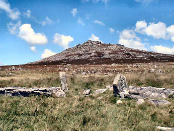 |
I have little doubt that this will be my favourite part of the Smugglers Way. I love the high ground of Bodmin Moor and this section includes some of the very best, the peaks of Roughtor and Brown Willy, the very first Bodmin Moor tors that I ever visited. Richard was still injured so I did this section, at the beginning of March 2009, as two solo out-and-backs to Brown Willy, the first from Davidstow Moor, the second from Jamaica Inn. This is a glorious walk with panoramic views from Roughtor and Brown Willy. To get the best out of those views, I suggest you make a couple of detours. Instead of heading straight down to the De Lank River crossing from Showery Tor, I suggest you first continue along the ridge to the southern end of Roughtor. And instead of heading down from the trig point on Brown Willy, I suggest you first continue to the southern end of the Brown Willy ridge. The route the whole way is entirely clear. Just be careful, at the beginning., not to cut a corner and get into Crowdy Marsh, which extends further east than shown on OS109. And after Brown Willy, where the route is between the hedge and the wire fence, you will find that, for much of the way to the gate leading to Tolborough Downs, there is easier walking on Codda Downs, on the east side of the hedge. Refreshments at Jamaica Inn. |
|
|
Ample free parking on
Davidstow Moor and at Jamaica Inn |
| INTEREST ALONG THE WAY: Lanlavery: before the rocks, look out for the grassy humps of the lost village and for two standing stones (one fallen). Roughtor: logan stones on Showery Tor and Roughtor itself and the Wessex Regiment memorial on Roughtor. Brown Willy: the massive bronze age burial cairn at the southern end of the ridge. Views: from Brown Willy include both coasts, GCHQ Steeple Point near Bude, clay country and Dartmoor. |
Jamaica Inn, Bolventor to Dobwalls - 11 miles
| I had expected this to be a relatively easy section with only one climb of any note, that up Brown Gelly. I had reckoned without the results of months of rain. The road bit to Dozmary Pool was obviously no problem. It is worth noting, though, that it should be possible to get off-road, using Dozmary Downs, Open Access land. Difficult ground started at Dozmary Pool Farm: boggy round the pool - where a gate was wrongly padlocked - deep slurry in Redmoor Farm's lane to Brown Gelly - the gate here was also padlocked - and heavily waterlogged going up Brown Gelly. The Driftway, running alongside Park Pit was also pretty soggy. From there, walking was easier. Draynes Common offered moderate views east to the high moor. The road to Lower Trenant was steeply downhill but a little boring. Walking was easy through Treverbyn Woods, above the Fowey River. Unfortunately, the last two miles from Treverbyn Bridge was, unavoidably, all on roads. Refreshment opportunities are all at Dobwalls. First Southern Gallery Coffee Shop just before the theme park, then Dobwalls Theme Park itself, and finally the Highwayman Inn (open all day) by the car park in Dobwalls itself. This was an enjoyable walk, marred only by the final road section into Dobwalls. | 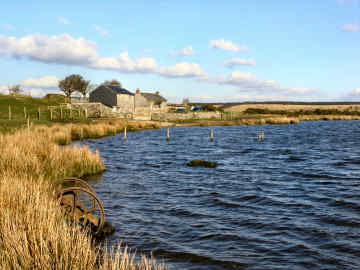 |
| Parking at Jamaica Inn and in Dobwalls |
|
| DRIFTWAY: In 2012, thanks to a farmer withdrawing his permission to use his land, the official route after Brown Gelly no longer uses the Driftway and Draynes Common. The new route uses road from the entrance to Park Pit to the Two Valleys Walk. I can offer a not very legitimate alternative from Brown Gelly to the Two Valleys Walk. You will find it in the course of my Bodmin Moor Round Walk Colliford Lake 02. |
| INTEREST ALONG THE WAY Dozmary Pool; legend has it as the lake into which Sir Bedivere threw Excalibur; The Loe near Helston makes a better candidate. Brown Gelly; only 1100 feet but great long views and five impressive bronze age burial cairns at the summit; there is also a massive hedge dividing Brown Gelly Downs north to south. The Driftway is an impressive remnant of an old drove road from Brown Gelly towards Draynes Common. Draynes Common disappoints; no antiquities. Treverbyn Woods is a lovely walk along the River Fowey in beech and bluebell woods. Old Treverbyn Bridge is a handsome packhorse bridge of 1412. |
Dobwalls to the Banjo Pier at East Looe - 11 miles
 |
Although there is a little road in this section, it is not much and is mostly at the start and finish. Although there is not a great deal of interest along the way, this is well made up for by a delightful woodland and river section. Pleasant small hamlets along the way include Scawn, Herodsfoot and Churchbridge. After Scawn Mill the route follows the West Looe River, much of the time with it in view. Then, after Herodsfoot you are soon into the first stretch of woodland. Unfortunately this is commercial coniferous woodland and, like all such, is essentially boring. This continues for a couple of miles with, surprisingly since you might expect to be going downhill all the way to the coast, a couple of longish uphill sections in it. Happily, once you are out of Gillhill Wood, you begin to get into broadleaf woodland and at Watergate you enter Kilminorth Wood with your first view of the tidal stretch of the West Looe River. This makes a delightful walk and will be even better with trees are in leaf and bluebells in bloom. Once in Looe you have to negotiate the massive Millpool car park and cross the bridge into East Looe. I suggest, however, particularly if the tide is in, taking a waterside walk along the West Looe side of the river to enjoy the views across the water to East Looe's working waterfront. The detour need add only half-a-mile or so. |
|
|
Many (seasonal) places to eat in Looe, incl. good fish and chips. |
| INTEREST ALONG THE WAY Dobwalls: a simple wayside cross at a crossroads half-a-mile south of Dobwalls. Herodsfoot: an attractive hamlet with an interesting direction sign. Trelawne Farm: just before Watergate, this was presumably once part of the Trelawn estate, birthplace of Bishop Trelawney, imprisoned in the Tower by James II and subject of Parson Hawker's Cornish anthem, Song of the Western Men. Kilminorth Woods: approaching Looe, a delightful walk through broadleaf woodland along the West Looe River. East Looe: the town has a fish market and Cornwall's third largest fishing fleet, despite a difficult tidal harbour. There are some interesting buildings along and near the waterfront, and some good places to eat, but the overall impression is of tourist tat. Beware expensive parking though, if you don't mind the extra walk, you could park for free along the front at Hannafore. |
|
|
|
|
|
|
|
|
|
|
|
|
|
|
|
|
|
|
|