


|
|
|
Prehistory and the Dark Ages |
|
|
|
|
|
| INTRODUCTION |
|
|
|
 |
WEST
PENWITH
Beyond St. Ives and Penzance is perhaps the most productive part of Cornwall for the seeker after antiquities. There is something of everything here: stone circles, massive bronze age barrows, quoits or dolmens, iron age villages, fogous and impressive menhirs or longstones. Antiquities reviewed include Zennor and Mulfra Quoits, Chun Castle and Quoit, Chysauster and Carn Euny iron age villages, massive Bollowal Barrow, Pendeen Vau fogou and the Merry Maidens stone circle. Many sites are on the hills and offer superlative views, sometimes, as from Chapel Carn Brea, as far as the Isles of Scilly. Image Bollowal Barrow. |
 |
BODMIN
MOOR
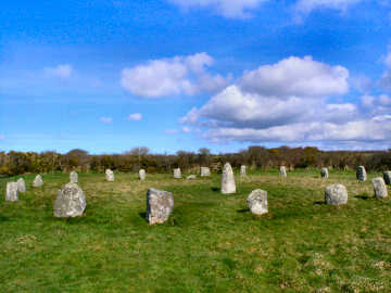
Cornwall's major area of open moorland lies roughly central to its eastern half, in an area loosely bounded by Camelford, Altarnun, North Hill, St. Cleer, St. Neot, Bodmin and St. Breward. It is an area of ancient hill settlements, many dating from the Bronze Age but continuing right through to the medieval period. On this page I have covered only the major sites; many others are mentioned in passing on my Bodmin Moor pages, mainly devoted to walks. The most concentrated area, around Minions, includes the Hurlers and Pipers, Trethevy Quoit, King Doniert's Stones and Stowe's Hill. Image Nine Stones Circle. |
 |
OTHER
SITES
These are spread all around the rest of Cornwall and include sites both on the coast and inland. The period is neolithic to medieval and the antiquities include Carwynnen Quoit, Long Cross Inscribed Stone, Roche Rock medieval hermitage and two stones which may or may not be what is claimed for them - the Arthur Stone at Slaughterbridge and the Tristan Stone near Fowey. What particularly strikes me is the number of hill forts and cliff castles; most impressive of these are Castle an Dinas hill fort and The Rumps cliff castle. St. Breock Downs is the most prolific area. Image Roche Rock. |
|
|
|
|
|
|
|
|
|
|
|
|
|
|
|
|
|
|
|
|
To someone like
me who likes to walk on the high moorland, where most are to be found,
Cornwall is a real treasure trove of antiquities. In that category
I include: neolithic and bronze age burial cairns, dolmens and stone
circles; iron age and early Christian era hill forts, small fortified
farmsteads, villages, fogous and inscribed stones; major standing
stones of indeterminate period; and a few medieval sites like Penhallam
Manor. In addition to those sites described here, a number of others
of minor importance will be found on my Walking
Pages, mostly under West
Penwith and Bodmin Moor.
Relatively few of these sites can be reached by car or with just a short
fairly level walk; these are shown in the index with a *star.
Some sites need good walking boots and stamina.
Other categories - bridges, Cornish crosses, cliff castles, boundary stones and old direction signs - can be found on my Miscellanea page. If you would like to consult the experts - and I don't include myself in that category - I suggest you may like to look at: The Modern Antiquarian or Megalithic Portal |
|
|
| Formed in 1985, Cornwall Heritage Trust is surprisingly little known. Its purpose is to protect land of particular beauty or historic, cultural or religious significance; and to preserve and restore buildings, artefacts and other items of similar importance. Its broader aims are to educate the general public and the people of Cornwall; to inspire, not least, Cornwall’s young people about Cornwall’s heritage and to encourage the realisation of its importance to future generations; to promote, with sensitivity, the heritage of Cornwall for the economic well being of the people of Cornwall; and to raise funds and achieve favourable publicity to these ends. Cornwall Heritage Trust also works closely with Cornwall Council's Heritage Environment Service and with CASPN, the Cornish Ancient Sites Protection Network. It also supports local heritage projects and the Historic Churches Trust, sponsors postgraduate students and school education programmes and even sponsors the annual gig races held at Newquay. Cornwall Heritage Trust does a valuable job very well indeed. I have been impressed by the care and maintenance of all the sites they own or manage and hope that all their other aims bear fruit. I wish them well in all their efforts. | |
| Cornwall Heritage Trust Website |
|
| Cornwall Heritage
Trust owned sites: Trevanion Culverhouse dovecote in Wadebridge,
Castle an Dinas iron age hill fort near St. Columb, Sancreed Beacon in
West Penwith and the impressive Treffry Viaduct in the Luxulyan Valley.
Sites managed for English Hetitage: Dupath Well near Callington, the Hurlers Stone Circles at Minions, Tregiffian Burial Chamber in West Penwith, St. Breock Downs Monolith (Men Gurta) near Wadebridge, King Doniert’s Stones near Minions, Trethevy Quoit neolithic portal dolmen at Darite and Carn Euny iron age village in West Penwith. Supported Local Heritage Projects include: St. Piran's Church aand Oratory on Penhale Sands and Perran Round at nearby Rose. |
| On a personal note, I am at a loss to understand why that particular brand of Cornish Nationalist that defaces English Heritage signs does not instead join Cornwall Heritage Trust and help them to acquire and care for all English Heritage sites in Cornwall - and care for the many other uncared-for sites. Perhaps the Trust's patronage by the Duke of Cornwall (the English Prince of Wales) offends them. Or perhaps their ends are exclusively political. Happily, Cornwall Heritage Trust has been able to persuade English Heritage to remove their branding at the sites the Trust manages. Vandalism has ceased there. |
CORNISH ANCIENT SITES PROTECTION NETWORK
 |
Until I did an antiquities walk from Lamorna in July 2007 I had never heard of the CASPN - in Cornish Roesweyth Gwith Hen Leow Kernewek. Then at the Merry Maidens Stone Circle I found a handsome polished granite tablet recording their interest in the site. It seems the Network was founded as a charity in 2000 to bring together the many bodies responsible (in some cases, irresponsible) for the care of Cornwall's vast number of ancient sites. CASPN was formed after a number of vandal attacks on prominent ancient sites. A large number of fairly disparate bodies are involved, amongst them National Trust, Cornwall Council’s Historic Environment Service, Cornwall Archaeological Society, English Heritage, English Nature, Cornwall Wildlife Trust, Cornwall Heritage Trust, Penwith District Council, Penwith Access and Rights of Way, Penlee Gallery and Museum, Madron Community Forum, Zennor Parish Council, Cornish Earth Mysteries Group, Pagan Federation, Pagan Moot, Meyn Mamvro and the Order of Bards, Ovates and Druids. The main focus seems to be the West Penwith area, as you might expect with its abundance of ancient sites. I haven't yet seen their tablets elsewhere but I hope to; I have to applaud their efforts. |
|
|
Information gleaned from CASPN's website |
Online Mapping - Cornwall Council's Mapping Web Site
 |
The recently introduced
'Right to Roam' legislation - long agitated for by the Ramblers Association,
and initially opposed by many landowners - has resulted in vast areas of
land all over England, Scotland, Wales and Cornwall being opened up to
the general public. Essentially these rights are for walkers only
- suits me. I used to find the Countryside Agency's Open Access website
an immense help in my Cornwall moorland walking, not just on Bodmin Moor
but also in West Penwith. Unfortunately the site has been messed
around with. Maximum scale is now much smaller and navigation is
quite awkward. As a result, it is no longer worth, as a walker,
using it in its current CRoW Access form. .
Fortunately, Cornwall Council has an excellent mapping web site, which I find better than the Open Access site ever was. It is easy to use, shows Open Access land, rights of way, path numbers should you wish to report problems, and is zoomable up to large scale. A word of warning on Open Access land.. I soon discovered that this may not be quite as straightforward as that. I have encountered barbed wire fences, locked gates and even one gate on Bodmin Moor, leading to access land, that has a 'no walkers' sign on it. And, in West Penwith, where moorland is lower, I have found impenetrable furze and bramble. So don't expect it to be easy. |
|
|
OS Explorer maps now show Open Access land as yellow |
|
|
|
|
|
|
|
|
|
|
|
|
|
|
|
|
|
|
|
|
|
|
|
|
|
 |
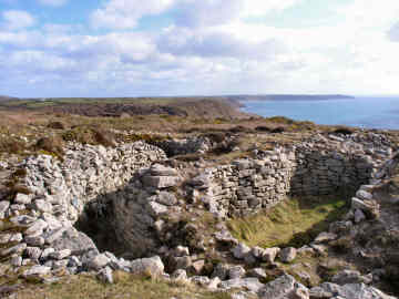
I know Carn Euny and Chysauster iron age villages well but had no idea that there was another with substantial remains in West Penwith. It was by pure chance, during a walk from Carn Galver car park - visiting the Nine Maidens and looking for boundary stones - that I came across Bodrifty. Within a badly degraded embanked enclosure are the remains of eight iron age roundhouses. Sadly an excavation in the 1950s did a lot of damage but the site, on a gently sloping hillside just north of Bodrifty Farm, is still well worth seeing. The location was apparently occupied in the Bronze Age but what you see now is what remains of occupation from 600BC to around 43AD. If you follow the yellow markers from the site you will find a good roundhouse reconstruction, done by Bodrifty Farm owner Fred Mustill. I believe this was done primarily for the benefit of school groups but anyone is welcome. I have passed through since on several occasions, particularly when walking the Land's End Trail. I have also learned that there are other similar iron age village remains in West Penwith, at places such as Trehyllys, Higher Porthmeor and Mulfra though these are even more degraded than Bodrifty and somewhat less accessible. |
|
|
By car, take a lane from New Mill to Tredinneck |
|
No one even knew this
was there until 1878 when Cornish antiquarian W C Borlase discovered it
under mining spoil. There are probably several similar barrows still
hidden under the rubble elsewhere along here. The barrow was in use
during both neolithic and bronze ages and includes an entrance grave, a
cairn, several individual burial cists and a number of ritual pits.
What you see is very striking: a central oval structure, 35
feet across with walls up to 10 feet high; all around this is a passage
six feet wide with outside walls forming a 'collar' of the same height.
The location of Bollowal Barrow is superb, just back from a 300 foot cliff with views north to Cape Cornwall and the Brisons rocks, south to Land's End and the Longships Lighthouse. On a clear day you can see the Isles of Scilly more than 30 miles away. You can drive to the site by taking the road from St. Just signed to Cape Cornwall for half-a-mile and then turning left on Carn Gluze Road for three-quarters of a mile. If you are fit, however, it is far more enjoyable to climb the steep coast path from the National Trust car park at Cape Cornwall. For refreshments close by you can't beat the egg and bacon baps at Cape Cornwall Golf Club, England's most westerly and most wind blown course. |
|
|
Barrow seen on a Cape Cornwall to Sennen walk |
Boscawen-un
Stone Circle and Trelew Longstone
 |
In July 2006 I did a figure-of-eight walk from St. Buryan in West Penwith, mostly to find several new antiquities. On the first, southern, loop to the coast I found Cornish crosses near Boskenna, one built into a hedge by a stile. On the second, northern, loop I sought out Boscawen-ûn Stone Circle and nearby Trelew Longstone. Boscawen-ûn is a circle of 19 stones, a leaning 20th at its centre, a little to the west of Boscawenoon Farm. I understand the nineteen stone circle is the standard Cornish formation, though few remain thus. If you want to arrive by car, there is room for about 6 cars to park on the A30, about 2 miles west of the St. Buryan turn; a small wooden sign points towards the circle. I was back again in March 2008 while walking the Penwith Round. This time I also sought out the Trelew Longstone, eight feet high, standing near the edge of a field of maize and visible from a lane leading to Trelew Farm from the south-east. If not walking, I imagine you can probably ask at Trelew Farm for permission to park and to visit the longstone. On both walks I enjoyed coffee and a snack in the pub in St. Buryan and admired the handsome church there, itself the possessor of two Cornish crosses. |
|
|
You can park on the A30 for Boscawen-un circle |
| I encountered Caer Bran for the first time in March 2008 when walking the Penwith Round. I really should have been there before, located as it is halfway between Sancreed Beacon and Carn Euny. However, the Ordnance Survy map gives the site little significance, and there is little about it on the web, so I hadn't previously given it a thought. I was glad I did so on this occasion. Apparently the site was largely furze covered but PAROW, the Penwith Access and Rights of Way group, has done some clearance recently though much more needs to be done. To my mind, the place is an oddity, an iron age hill fort with - according to a Cornwall Archaeological Unit 1990s survey - several bronze age ring cairns inside its 240 foot diameter outer rampart. What I saw seemed shaped more like longhouses! The name could mean Crow's Castle or it could take its name from nearby Brane (Bos Vran - the House of Bran). Or could it be anything to do with the Rialobran commemorated on Men Scryfa near Men-an-Tol and the Nine Maidens circle? I feel this is a site that might benefit from the attentions of Time Team and perhaps from being put in the care of the Cornwall Heritage Trust, which has done such a good job elsewhere. Anyway, it's a spot well worth visiting if you are in the area. There are long views though less than those from nearby Sancreed Beacon. |  |
| Off lane from Grumbla Common, opp. Caer Bran farm |
|
 |
Take a look at the
large scale Ordnance Survey Explorer series map of West Penwith - Cornwall's
sparsely populated far western extremity - and you will see the landscape
littered with the symbols for prehistoric sites. The words in gothic
script tell you just how heavily populated these parts were 2000 years
ago - settlement, hut circle, farmstead, homestead, tumulus, cairn, quoit.
On a bright sunny day in early October 2004, I took myself off to West
Penwith in order to investigate several of these ancient sites - Carn Euny,
Chun
Castle, Chysauster, and Chapel
Carn Brea. Most interesting of all these are the two hillside
iron age villages, Chysauster and Carn Euny.
Carn Euny was only discovered by 19th century tin miners. Dating from around 500BC to 500 AD, it consists of early round houses and later more sophisticated courtyard houses. What looks like an extremely elaborate house turns out to be the later ruin of a tin miners cottage! The site has been less excavated than Chysauster and retains great charm. Most impressive feature is an enormous and fully excavated 'fogou', maybe an underground storage chamber. It is possible to drive almost to the site but much more enjoyable to park below Chapel Carn Brea and walk a mile, passing an old clay pit and St. Euny's Well, one of those wells where people tie strips of cloth in the trees, in prayer for the sick or remembrance of the dead. |
|
|
Tregeseal
Circle on Carnyorth Common, south of Trewallard
 |
In early July 2006 I headed for West Penwith in search of more antiquities. After spending some time at Sancreed, I parked at Geevor Mine in Trewellard - not far from St. Just and Cape Cornwall - where I returned later to make a report on the museum, and enjoyed a pleasant and an easy four or five mile walk. I found more than I bargained for - at Sancreed Cornish crosses, a holy well and a bronze age barrow; on and around Carnyorth Common, boundary stones, a line of holed stones, a stone circle, an abandoned farmstead and a relatively contemporary farm with ancient field walls. I have to confess that I failed to find the stone circle first time and had to drive up rutted tracks later to find it from a different direction! I was back later on foot, walking the Penwith Round. On the way I drove through Tregeseal village which itself was quite a delight, its colourful cottages and gardens nicely tucked away from the St. Ives - St. Just road. Sadly this circle of around twenty stones, having been restored, was rapidly being engulfed again in bracken. It had turned quite dark and drizzly when I got here, so I got no worthwhile photo then. However, I have been back many times since and discovered that the site is being maintained again, by Cornish Heritage Trust, and is in much better shape. |
|
|
The Land's End Trail passes through here |
| When I walked here with my sister Mary in March 2008, on my first stage of the Penwith Round, I was sufficiently puzzled by what OS102 clearly shows as Castallack Round that I returned a few days later to take another closer look. The Penwith Round route instructions are, I think, misleading, suggesting you turn right (north) on a grassy path. There is no grassy path and the entrance is before the track becomes a path and just before a wooden gate. Before I returned, I checked the usual sources (The Modern Antiquarian and Megalithic Portal) and found nothing useful. What I found on site was a large level field, a little higher than the land to its north, surrounded by a massive hexagonal wall. The image on the right shows what may have been the entrance. The site was definitely made by early man, presumably for occupation since the site was levelled. The name is confirmation, the Cornish Castallek meaning 'fortified' according to Craig Weatherhill. The wall, much degraded, stands about seven feet high in places and as much as six feet thick. Since there is supposed to be a Bronze Age hut circle in one corner - I couldn't find it - perhaps the site is of that period. What it certainly isn't is a conventional Cornish round; you only have to look at Piran or Pencarrow Rounds to see the total difference. A puzzling and fascinating site. |  |
| Signed path from Castallack Farm. Site on R before gate. |
|
Chapel Carn Brea
Bronze Age Tomb
 |
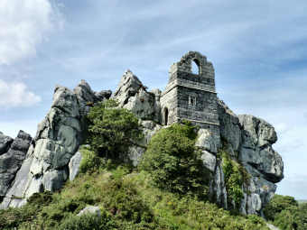
Even if you have no interest in antiquities, this is a spot that is well worth visiting for its location and views. Chapel Carn Brea - not to be confused with Carn Brea at Camborne/Redruth, is Cornwall's most westerly hill. Although rising only to 650 feet, the panorama is quite stupendous. Below you spreads a patchwork of small fields, the settlement of St. Just, and Land's End and both coasts. You may see, as I did, planes flying into tiny Land's End airfield. To the southeast you can see Lizard Point, 21 miles away; to the west you can see Longships Lighthouse off Land's End; to the southwest you may see the Isles of Scilly, some 31 miles distant. If you are interested in antiquities and history, what you will find at the very top of the hill is a Bronze Age chambered cairn, a vast burial mound covered with rocks. It is very badly disturbed and degraded; a medieval hermitage was built here, using stones from the cairn and, in the second world war, a radar station was built on it. Fairly nearby is another odd feature, close by a rocky tor, which none of the authorities I have consulted mention but which I think is an earlier neolithic long barrow. There is also a charred area where local pagans burn midsummer bonfires. The hill is fairly steep but easy to climb. There is a car park at its foot from which you can also walk to Carn Euny iron age village by way of St. Euny's Well. |
|
|
Car park on road from Crows an Wra to Land's End airfield |
 |
Where Carn Euny has only been partially excavated, Chysauster (its name is actually 'Chy Sylvestra', meaning the houses in the wood) has been more fully excavated since its discovery in around 1860, much the same time as Carn Euny. Unlike earlier Carn Euny, Chysauster dates from around the birth of Christ and was occupied during the Roman period. Being later, it is more sophisticated, consisting of nine courtyard houses, mostly fairly fully excavated. As you can see from the photograph, its substantial walls rise to around eight feet. The houses are known as 'courtyard houses' because the four or five rooms, backed by massive stone walls, surround an open courtyard. They are entered by a long entrance passage, believed to have been gated, giving a good degree of privacy. In the centre of the main room, a stone in the floor has a hole where a timber would have supported a thatched roof. In evidence are hearths, corn-grinding stones and covered sewers. Each of the houses appears to have had its own terraced garden. The fogou, unlike that at Carn Euny, is in a ruinous state and is not open. The site is in the care of English Heritage so there is a small entrance fee. The walk from the car park to the site is a gentle climb of about quarter of a mile. There is a small shop in the reception hut but no refreshments. |
|
|
B3311 Penzance-St. Ives, turn NW at Badgers Cross 1½ miles |
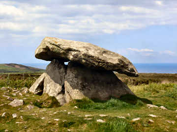
| Chûn Castle and the nearby Chûn Quoit neolithic burial chamber are among Cornwall's least accessible ancient monuments. Footpaths to the site are not signed and you will need to find Trehyllys Farm (please ask the farmer's permission to park) near Great Bosullow, a mile off the Penzance to Morvah road. It is worth it; the ragged ruins of Chûn Castle suggest the former size of this iron age fort. Almost 200 feet in diameter, its tumbled walls must have been six feet thick - and in 1951 Jacquetta Hawkes recorded that, in living memory, its walls had stood twelve feet high. She believed it to have been connected with the tin trade. While you will need to use considerable imagination, this is an impressively dominant site, which must have been much like an Irish rath and similar to Staigue Fort in Ireland's County Kerry. Use OS Explorer Sheet 102, whether coming by car or in the course of a hike. You could include a visit to nearby Men-an-Tol stones. |
 |
 |
|
|
|
| Some time after writing the above report I discovered another longer, but probably better route to Chûn. Park to the east of the site at Woon Gumpus Common on the road south from Pendeen. Paths are cleartly waymarked and lead gently to Chûn, which is on the Land's End Trail. |
Lamorna
- the area to the west of the village
 |
Ever since December
2003, when my sister Mary and I did a round walk from Lamorna
that included coast, Boskenna Cross and the Merry Maidens, I had been meaning
to return to find the many other antiquities in the area. At last,
in July 2007, I did it. After an early lunch at the Lamorna Wink
Inn I left my car in their car park (with permission) and set out up the
hill opposite to a path that took me west past three farms - Tregurnow,
Rosemodress and Tregiffian - then north-west to Boscawen Ros Farm, the
original home of the Falmouth's of Tregothnan. There I found my first
standing stone in the middle of a field. Continuing north-west I
found Boskenna Cross on the main road, then on up a lane to Moorcroft Cross.
From there by a path south-west from Choone Farm for massive Goon Rith standing
stone. On to the main road for Tregiffian Long Barrow (the cup marked
stone is a concrete copy of the original in the Royal Cornwall Museum),
then another cross, the Pipers standing stones and Merry Maidens stone
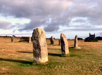
circle, one of Cornwall's most complete with 19 regularly placed stones.
Oddly, you cannot see one Piper from the other and you can't see the Merry
Maidens from either, despite proximity. Yet you can see the Maidens
from Goon Rith standing stone. Around 6 miles and very enjoyable.
For full directions of a longer walk see Coastal Round Walk 15 |
|
|
You can park at Lamorna Cove or near the Merry Maidens |
| Located just off the road from Penzance and Madron to Morvah, Lanyon Quoit, along with Trethevy Quoit, is just about Cornwall's most accessible quoit. A late neolithic portal dolmen or chambered tomb, it was brought down in a great storm in 1815. When re-erected in 1824 one upright was broken so now it is like a tripod stool. Before the storm it was apparently possible for a horse rider to pass beneath the 13 ton capstone; now perhaps only a small child on a miniature pony could manage to pass beneath it. Lanyon Quoit, in the care of the National Trust, is only a few yards from the road and is approached by a stile. Park in the small lay-by just round the corner, north of the stile. The area just north of Lanyon Quoit is rich in fascinating antiquities. If you park at Bosullow Common, two loops could take in, to the west, Chûn Castle and Quoit and Bosullow Trehyllys iron age settlement (on private land) and, to the east, Men-an-Tol, Men Scryfa, the Four Parish Stone, the Nine Maidens stone circle and Ding Dong mine. And a litle way down the road to Penzance you will find Madron Holy Well and Chapel, tucked away in light woodland a little way from the road. Altogether, an area well worth exploring by those interested in Cornwall's amazing antiquities. |
 |
| Park in a small lay-by just north of the quoit. |
|
Maen Castle - Cliff Castle near Land's End
 |
When I was last here - in September 2005 - I could never have guessed that Maen Castle was perhaps the most impressive cliff castle in Cornwall, Treryn Dinas notwithstanding. Then the whole site, except the entrance, was covered in bracken and furze and, had I not been looking for the wreck of the RMS Mulheim in Castle Zawn, I would never even have spotted the tiny National Trust sign. On this occasion, in April 2008, I was pleased to discover that the National Trust had cleared the site, exposing what seems to be four concentric rings of wall. The main stone-built wall, through which you enter, must have been absolutely massive; its six to eight foot width suggests a considerable height. Clearly there has been a great deal of cliff erosion - this is probably the most storm-swept part of the Cornish coast - and I guess this must have been a gigantic fort in its day. It is generally believed that it was constructed in around 500 BC and remained in occupation for almost 1000 years. Access along the coast path is fairly easy. It is about halfway between Sennen Cove and Land's End. There is an easy 200 foot climb from Sennen Cove; from Land's End it is more or less level walking. The best place to eat nearby is Sennen Cove where, at one end of the front is the relatively expensive The Beach café, at the other end is a café with good value breakfast type food. |
|
|
Marked on OS Explorer sheet 102 |
| I have been back since and found the site very overgrown again. Perhaps it depends on the time of year. |
| Off the narrow road from Morvah to Penzance is one of Cornwall's most fascinating ancient monuments, Men-an-Tol. Park opposite the small former chapel at Bosullow and walk up a well-made farm track, leading towards Nine Maidens Common, to find the site which is signed over a stile on the right halfway along the track. Two rather phallic uprights stand either side of an upright circular stone with a large hole through it. It is this 'stone with a hole' that gives the site its name. Almost certainly formerly part of a burial chamber, the present upright stones stand either side of the circular stone which would probably have been the entrance to the grave. The stones are said to have curative rather than fertility properties. Passing through the hole will cure a child of tuberculosis or rickets, an adult of rheumatism. On the way along the lane, elaborate stone walls enclose small fields, close to a ruined farmstead and a recently abandoned one. Further up the lane, on the way to the Nine Maidens, Men Scryfa, an inscribed stone, stands in a field on the left. You can also follow the road towards Penzance to encounter other ancient sites - Lanyon Quoit just a mile on, Madron Chapel and Wishing Well another 1½ miles. The well is one of those where people tie strips of cloth in the trees, in prayer for the sick or in memory of the dead. | |
| Parking at Bosullow Common by the lane to the site |
|
Nine
Maidens Stone Circle in West Penwith
Not to be confused with Nine
Stones of Altarnun or with Nine Maidens stone alignment near Wadebridge
 |
Standing high on gorse and heather moorland in West Penwith, not far from Men-an-Tol, Nine Maidens stone circle must be one of those, like the Rollright Stones in the Cotswolds, where you cannot count the stones. Look at Megalithic Portal or the Modern Antiquarian and you will find many differing reports of the number of stones there were and are here. At its restoration in 2004, three were said to have been re-erected to add to the existing six. In September 2006 Jane and I counted eleven. If Nine Maidens followed the same reported practice as other West Penwith circles, there would originally have been a circle of nineteen stones with, like Boscawen-ûn circle, one standing stone in the centre. The site has a wonderfully remote feeling, high on Nine Maidens Common with only the rugged heights of Carn Galver visible to the north and a glimpse of the remains of the once renowned Ding Dong mine to the south. It is, however, a relatively easily accessed site and, unlike many parts of the West Penwith Moors, you may well encounter other visitors. I have passed through here on many occasions since my initial visit on a short walk with Jane. If, like me, you choose to walk the The Land's End Trail, you will pass through here on the second stage. |
|
|
Park at Bosullow Common and follow the track north-west |
 |
In Cornwall the word is 'fogou', in Scotland 'earth house', in France 'souterrain'. No one has any idea of the purpose of such an underground structure. Guesses include grain store and defensive retreat. Almost certainly not a burial site. I managed to miss both Pendeen Vau and Boscaswell when walking in mid-October 2007 but found both repeating the walk with sister Mary in late October. The fogou is in the farmyard of Pendeen Manor Farm - so ask permission and be prepared to ease your way past the cows and through slurry. It is worth it as you can negotiate the two main chambers easily; the second also has a small entrance. A rough subsidiary chamber has a very low opening and I did not try to enter it. If you want to, someone has helpfully put a board in place that you can crawl along. But beware, it is very muddy and messy so if you do go in, be suitably clothed. There are said to be eleven fogous in Cornwall, all in West Penwith or on the Lizard Peninsula, all dating from the late Iron Age. The most easily accessible one I know is that at Carn Euny, open all year. There is another to be found at Chysauster nearby but English Heritage does not allow access to it. Close to Pendeen Vau fogou is another at Boscaswell, now owned by the National Trust. Some say the best of all is Halligye Fogou on the Trelowarren estate on the Lizard. |
|
|
Pendeen Manor, down farm track off lane to Pendeen Watch |
| I had no idea this existed until I spotted a long car park, just a little west of Sancreed church. Wondering what it was for, I investigated and found an information board telling me that high on the hill were bronze age remains. The site is rather over-run with heather and bracken so it is difficult to know exactly what you are seeing. There appeared to me to be just one massive barrow with two or three possible burial chambers exposed on top. Quite an oddity. Elsewhere is said to be remains of a bronze age hut but I couldn't find it. Views are great from up here, as so often on the high ground in West Penwith, on this occasion taking in St. Michael's Mount, Lizard Point and the ruined engine house at Ding Dong mine. Quite apart from this site, there is a lot more of interest to the antiquarian in the immediate area. A round walk of no more than five miles could include Carn Euny iron age village, Brane chambered cairn, Caer Bran hill fort and the small village of Sancreed. Sancreed has a charming church with several Conish crosses and a nearby holy well. Extend the walk by a couple of miles and you could also include St. Euny's holy well and the massive cairn on Chapel Carn Brea. | |
| Parking in the long lay-by by Sancreed Beacon |
|
Tregiffian Vean Chambered Cairn near Land's End
| The fact that there is a better known Tregiffian neolithic long barrow close to the Merry Maidens in the Lamorna area confused me for a long while. So in April 2008, when doing a walk from Land's End, I looked at the OS map, saw that 'chambered cairn' was shown between Higher Tregiffian and Tregiffian farms, and decided to include it in my walk. It was easy to find, in a long field through which a path runs between the farms and, despite its small size, visible from quite a distance. When I got to it, my first thought was that this was no chambered cairn at all but just a heap of stones that a farmer had piled in a field. However, when I got home and looked it up on the web I found a posting by Pure Joy on The Modern Antiquarian , quoting Craig Weatherhill's book Belerion, Ancient Sites of Land's End as follows: "This barrow has suffered dreadfully and it is only a shadow of the fine and unusual monument excavated by W.C.Borlase in 1878. It was then a kerbed mound 6.4m in diameter, containing a rather odd-shaped chamber. This was 2.4m long, 0.9m wide and just 0.5m high, but its inner end opened out to a width of 1.2m and a height of 1.0m. Like the tomb at Tregeseal the entrance was blocked by a single slab. The roof of the chamber consisted of three slabs and the tomb contained ashes and an urn". Sad that an important ancient monument - it is of the Scillonian type - should have been allowed to be so badly damaged. |  |
| You can probably ask permission to park at Higher Tregiffian |
|
 |
This must be the largest of Cornwall's cliff castles. Depending on who you believe, there are either three or four lines of ramparts. I make it three. A massive landward rampart (right on the coast path) as much as twenty feet high, an inner double bank and ditch, and a small seaward rampart, which is approached by a 'bridge', just before the incredibly rocky headland. There are said to be remains of two hut circles beyond this seaward defence. I find this a puzzling place. Why should anyone who could build the vast outer defences risk being trapped between their tiny final rampart and this rocky headland, with no way to escape. Is it possible that 2000 years have seen massive erosion here, changing the headland beyond recognition. Whatever the reason, it is a most impressive place. It is worth climbing the rocky headland to find the famous Logan Rock - I couldn't make it in the high winds of late March 2008. The National Trust has made a fair job of clearing the site and there is an easy level path from Treen village. For once I disagree with Craig Weatherhill's thoughts on place names. Treen may not mean 'the farm by the fort', it more likely means 'the farm by the (bank and) ditch'. But I do agree that the cliff castle's name is now derived from the village name - 'the fort by Treen'. |
|
|
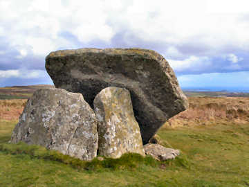
| Believed to be remains of Neolithic burials, where the mound has weathered away, these quoits are known elsewhere as Cromlechs or Dolmens. Cornwall's best known are Lanyon Quoit in West Penwith and Trethevy Quoit on Bodmin Moor. This is probably just because they are easily accessible by car. Zennor and Mulfra Quiots, like their West Penwith companion Chûn Quoit, are accessible only to those to like to walk the hills. My own view is that, of all five, Zennor is the finest - and the most unusual for having several standing stones to its front. From Zennor Quoit you can see the north coast, from Mulfra you can see the south coast and St. Michael's Mount. |
|
|
 |
|
|
|
| In early April 2006,
having finished walking Mark Camp's Copper Trail, I went back to Five Lanes
to investigate an area that I had looked at briefly on the trail and that
had attracted me when studying the Ordnance Survey map. This lies
just off the Copper Trail, to the south of Five Lanes and the A30 highway.
In a fairly complex walk I took a lane through Tregirls and up onto the
moor at Eastmoorgate, having checked first that East Moor is an unrestricted
Open Access area. Once on the moor I headed up 1100 foot Fox Tor
- great views in all directions - where there are traces of a boundary
bank and the outlines of former long houses. Then westwards to find
what had been a massive boundary bank and on to the south-east up another
hill for a stone row and a couple of degraded cairns. South then
for the Greymare Rock (not really an antiquity) and hut circles on Carey
Tor. Finally northeast to find the Nine Stones circle. My one
failure was that I could not find a line of Altarnun parish boundary stones,
though I had previously found one near Clitters on a Copper Trail
walk. A great walk and fascinating, if mostly rather rudimentary,
remains. Afterwards I enjoyed another great, and good value, beef
and onion baguette at the King's Head at Five Lanes.
Full directions for a similar walk at Bodmin Moor Walks, Walk A30 05 |
|
| On Ordnance Survey Explorer sheet 109. |
|
| In January 2009 I walked again in this area. This time I succeeded in finding the boundary stones which mark the moorland boundary between the parishes of Altarnun and North Hill. How I missed them before I shall never know; they head clearly in two directions from Nine Stones Circle. For more on the boundary stones and on Clitters Hill see below |
Fox Tor, Nine Stones
and Clitters Hill
 |
On a bitterly cold,
but gloriously sunny, day in January 2009 I decided to revisit Fox Tor
and East Moor. This time to try to find the long line of boundary
stones - marking the boundary of the parishes of Altarnun and North Hill.
Again, I parked at Five Lanes and approached Fox Tor from Eastmoorgate.
When I had looked for the boundary stones before I had started in the south-west,
south of the Greymare rock. This time I headed from the East Moor
ring cairn east towards Ridge and easily found the stones on a low ridge
running north-east directly towards the Nine Stones of Altarnun circle.
At the circle the row veers a bit east and heads downhill to the
corner of Clitters Plantation and the path from Newton to Clitters.
As on Fox Tor, East Moor, Carey Tor and Ridge, there is a lot of archaeology
on Clitters Hill. Not just that shown on OS109 - settlement, field
system and hut circles - but at least one more probable cairn. At
the path below the hill I then took a field path north down to a ford and
a wooden footbridge across the little River Lynher. I then found
Upton Castle. On private land, it is very badly overgrown but seems
to be a small 'keep and ringwork' castle. I made my way back
to the car by Upton Barton farm and paths to Trenilk.
Full directions for a similar walk at Bodmin Moor Walks, Walk A30 05 |
|
|
On OS Explorer 109. Mostly Open Access land |
King Arthur's Hall - On OS109 at grid ref: 12963/77623
| This is a very puzzling site. There is a rectangular enclosure bank, over six feet high in places and some 160 feet by 65 feet. The inside is lined with apparently random stones, upright, angled or lying flat. Romantics would have us believe that the enclosure was once roofed, hence its name, but its sheer size makes that most unlikely. Its age is a puzzle; its existence was first recorded in 1584 when it was apparently already known as King Arthur’s Hall. According to Craig Weatherhill, in his Cornovia, it could date from the Neolithic period, as do similar enclosures in Ireland and Wales. Some have suggested that it could simply be a cattle enclosure but its interior wetness makes that unlikely. It is noticeable that inside the bank and stones is a well defined rectangle of mares tail grass, inside that a rectangle of cotton grass. This suggests a lining of some sort that holds the moisture. Could it just be that it was a man-made pond or even reservoir to water the cattle on the moor or provide a water source for settlements nearby. Whatever its purpose, the sheer size suggests a place of some importance. It still feels like a special place, perhaps because of its location. Despite nearby farms and villages, you feel total isolation on the high moorland, your views of the higher land of Garrow Tor, Rough Tor and Brown Willy only heightening that feeling. | 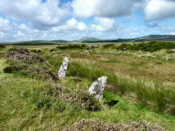 |
| Detailed walk incl. King Arthur's Hall; go to St. Breward Walk 03 |
|
| There is a slightly similar, but much smaller, enclosure at 20283/75596 at the south-western corner of Smith's Moor, on the way to Goodaver Stone Circle. I like to call it 'Arthur Smith’s Hall'. You will find reference to it on a Bodmin Moor Walk. |
Return
to Bodmin Moor
Return
to Antiquities
Return
to Home Page for Cornwall Reviews Contents
|
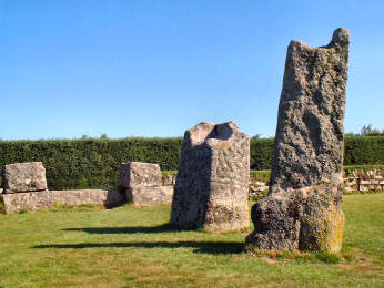
In a nicely maintained granite-walled enclosure, on the minor road between Doublebois and Minions, are a couple of granite standing stones, with handy car parking by the site. It is unclear whether they were always two or whether they are one broken in two. You will find it impossible to read the inscription carved in the granite but a plaque nearby carries the information: 'King Doniert's Stone. Men Myghtern Doniert. These two granite cross bases (if they are indeed separate) are decorated in the late Ninth Century style and probably date from that time. The shorter stone carries a Latin inscription "Doniert Progant Pro Anima", saying "Doniert ordered [this cross] for [the good of] his soul". Doniert was probably Durngarth, King of Cornwall who was drowned in AD875. The two stones have rectangular sockets on their top and probably carried wooden crosses'. Durngarth apparently drowned in the River Fowey near Draynes Bridge (a mile west), possibly at scenic Golitha Falls, reviewed on my 'Countryside' pages. Other sites to visit around Minions include Trethevy Quoit, the Hurlers and Pipers stones and Stowe's Hill. It is also well worth following a quiet signposted footpath along the old mineral tramway south towards the village of Crow's Nest to find the gaunt ruins of South Caradon Mine and the pleasant Crow's Nest Inn, where we have enjoyed many a hot baguette. |
|
|
OS109. Site in the care of Cornwall Heritage Trust |
| Detailed directions for a round walk from Minions, taking in Trethevy Quoit, St. Cleer Holy Well and King Doniert's Stones, can be found on my Bodmin Moor Walks page. The walk is an easy one of about 6¾ miles. |
The Hurlers and Pipers Standing Stones
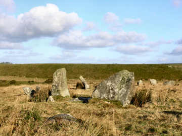
| There is a large complex of standing stones at Minions on Bodmin Moor. The Pipers are two tall stones. The Hurlers are three stone circles, one recumbent. Its two standing circles are of 100 and 140 feet in diameter. Legend has it that the Hurlers were playing a game somewhat similar to baseball. They made the mistake of playing on a Sunday and were turned to stone for their sins. The Pipers, who were providing the musical accompaniment, suffered the same fate. It is said you can only count the stones by placing a loaf on each then collecting and carefully counting them. Unfortunately, the devil sometimes likes to steal a loaf or two so counting can be more than a little difficult. The same sort of tale is told of the Rollright Stones in the Cotswolds and of others in England. And see below for the Crystal Pavement |
 |
 |
|
|
|
The Crystal Pavement at the Hurlers
 |
In mid-September 2013 Cornwall Historic Environment Projects, led by archaeologist James Gossip, unearthed an antiquity in the Minions area not seen since 1938 - but believed to be some 4000 years older than that. This was the so-called Crystal Pavement, linking the two standing stone circles of the Hurlers. I visited the site a couple of times during excavation and was disappointed for several reasons. As you can see from the photo, the weather was rather misty, not conducive to photos. Because of the name, I had expected the pavement to be of quartz; instead it was simply of the local granite with no suggestion of crystal to it. It was also shorter in length than I has expected, failing to reach either of the circles; I am sure the 1938 photo shows a longer, more complete length of pavement. I also felt that, considering that we taxpayers were footing the bill, the site was not very visitor friendly. I felt guilty about asking permission to enter the site to get photos but it certainly wasn't possible to take them through the security fence. The fully excavated pavement only remained fully visible overnight; the next day it was covered again so there is nothing to see now. |
|
|
More information see Caradon Hill Area Heritage Project |
Stannon and Fernacre Stone Circles
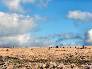
| On a cold sunny day in late January 2008 I set off to find three stone circles on Bodmin Moor - Stannon, Fernacre and Louden. Stannon is to the south of the china clay pit and I was able to park within 100 yards. From there I headed south-west for Louden Hill circle. I didn't find it this time but did find it later in the course of my Camelford Walk 01. So I headed for Fernacre circle, clearly visible from almost a mile. On the way I encountered numerous cairns and standing stones and two cists, the Steping Hill one visible from a distance. Then, after climbing Roughtor and exploring the settlement on the hill's south-west side, I headed off to Louden Hill for the logan stone. From Louden Hill, if you look across to the nearest hill westwards, you might think you see quoits and standing stones but the hill is a Stannon Pit spoil heap and they have been placed there for fun. But what I did find, at the western base of Louden Hill, close to the Stannon Pit boundary fence, was an impressive (I assume) hut circle, its walls two or three feet high and grass covered. Finally, I followed the boundary of Stannon Pit to find the impressive Stannon stone circle. |
 |
 |
|
|
|
 |
The most concentrated group of interest on Bodmin Moor is on the south-eastern edge of the moor at Minions. A short walk north from the western car park will bring you to The Hurlers and Pipers, ancient standing stones. Legend has it that the three stone circles of the Hurlers are teams of sportsmen, turned to stone for playing hurling on a Sunday; the nearby two Pipers standing stones provided the musical accompaniment. A longer walk to the north leads to a fascinating area at Stowe's Hill. Here, south of the summit, is Daniel Gumb’s Cave where a simple stone-worker, self-taught mathematician, carved a Euclid theorem on a rock. Climb to the top of the hill, around 1300 feet above sea level, one of the moor's highest points, and you will find the quite amazing Cheesewring, a natural granite outcrop, precariously poised above a quarry. Beyond is a massive stone-walled pound, possibly bronze age, and beyond that a larger walled enclosure. Views over the moor are glorious; to the north you are looking to the high tors of Brown Willy and Rough Tor, to the south you can see the sea as far as Dodman Point, to the east you see Dartmoor. South of the hill, beyond a massive deep ditch, is first a degraded cairn and then the famous Rillaton bronze age barrow. The cist, where the gold Rillaton Cup (original in the British Museum, copy in Royal Cornwall Museum) was discovered, is visible on the barrow's east side. |
|
|
Simple Stowe's
Hill round walk see below |
| STOWE'S HIIL ROUND
WALK FROM MINIONS - about 3 miles
Just to the west of the western car park at Minions a track leads north-west to the Pipers standing stones. From here go east to the Hurlers stone circles then roughly north-east to a low hill. Here is Rillaton bronze age barrow, just to its north a degraded cairn. Now head roughly north-west, directly towards the summit of Stowe's Hill. After crossing a massive embanked ditch (I don't know its purpose) you can see Daniel Gumb's cave ahead. From the cave, climb Stowe's Hill to the Cheesewring to explore the amazing rock formations within the bronze age walled pound and enjoy the wonderful views. If you then descend the hill by the same route, past the massive ditch, you can turn east on a track to cross the former tramway to Cheesewring quarry and follow the left-hand hedge down to another tramway. Turn right on this to return to the eastern car park in Minions village. Another mineral tramway leaves Minions heading south for Crow's Nest. |
| I sought out Cornwall's largest - and most unusual - stone circle during a walk in September 2006 that took in King Arthur's Hall, Garrow Tor and Hawk's Tor. The Stripple Stones is a most unusual site because it is Cornwall's only stone circle standing within a henge (circular bank and ditch) - if there were other such henges they have degraded so much as to be unidentifiable these days. The henge is about 225 feet in diameter but now quite shallow and degraded. It seems that no one can agree about how many standing stones there originally were in the circle. Estimates vary from 15 to 28. Only four stand now and the central longstone lies flat. It would be good to see the site cleared and the lost stones re-erected - if they could all be found. Pity is that the location is quite difficult to access so that is unlikely to happen. Location is on the lower southern slopes of Hawk's Tor. It lies on private land but it is to be assumed that the farmer doesn't mind if enthusiasts use his unlocked gates. I was able to approach it from De Lank water works, climbing access land over Carkees Tor and skirting Shallow Water Common before heading south to pass the east side of Hawk's Tor. A fascinating spot and well worth the fairly moderate effort involved in geting to it. |  |
| On OS 109 at grid ref: 143/755 |
|
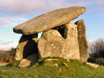 |
Trevethy Quoit is
the best example in Cornwall - and one of the best that you will find anywhere
- of what the archaeologists describe as a neolithic portal dolmen, a massive
4000 year old burial chamber of stone construction that would once have
been covered in earth. Quoit is the Cornish word for this kind of
monument. Seven vast slabs of Trethevy Quoit survive of which one
has fallen into the tomb, causing the great capstone (it weighs around
ten tons) to slope at an angle that adds character, as does the neat hole
drilled through one corner - one suspects that this may have been
done in Victorian times in order to put the slab back on top after it had
fallen. Another oddity is that the upright 'closure' stone has a
bottom corner cut away, apparently in order to allow the chamber to be
entered. When looking for Trethevy Quoit, you will find it poorly
signed. When you make the designated turn in Darite village, you
will then need to make an immediate unsigned right to find it.
There are several other ancient sites nearby worth visiting: the Hurlers stone circles and Pipers standing stones just north of Minions and King Doniert's Stones two miles south-west of the same village. Nor should you miss the wooded River Fowey at Golitha Falls about four miles south-west of Minions, a delightful spot with beech woods and impressive waterfalls. |
|
|
Small amount of parking by the triangular green nearby |
| Detailed directions for a round walk from Minions, taking in Trethevy Quoit, St. Cleer Holy Well and King Doniert's Stones, can be found on my Bodmin Moor Walks page. The walk is an easy one of about 6¾ miles. |
|
|
|
|
|
|
|
|
|
|
|
|
|
|
|
|
|
|
|
|
|
|
The Arthur
Stone at Slaughterbridge, the legendary Camlann
 |
I first saw the famous
Arthur Stone in the 1990s and had failed to get a photo of it. I
had been meaning to go back but had been a little put off by the idea of
the 'visitor attraction' Arthurian Centre now on the site. At last,
in August 2007, I did return on a day sunny enough to get a photo of sorts,
not easy in its heavily wooded valley site.
The stone, a memorial stone, probably of the early 6th century, may once have stood on a mound above the River Camel only to be cast down to its riverside position after the Saxons defeated the Cornish here in AD823. Its inscription reads LATINI IC IACIT FILIUS MA[…]RI but what makes it unusual is that an Ogham inscription, now illegible, also contains the name Latini. Nothing about Arthur here; the association comes from the legend that Slaughterbridge was Camlann, the site of Arthur's death at the hands of Mordred, somewhere around AD540. The Arthurian Centre contains a romanticised exhibition and video but does bring together most of the Arthurian literature. On the way from there to the stone I was fascinated by the archaeological dig of Melorn village, once part of the Worthyvale estate (the Tudor house still stands) and by the restoration of Lady Falmouth's Garden by the river. The stone and the archaeology make the £3 charge for a visit well worthwhile. |
|
|
On B3314, ½ mile east of B3266 Camelford - Boscastle |
| I strongly recommend looking at two websites for much more detailed information. Joe Parsons' (could it have been his ancestors who farmed Lord Falmouth's estate here in the early 18th century?) excellent and highly detailed Arthur-Online site; and archaeologist Nick Hanks' own informative site about his digs of Melorn village and Lady Falmouth's Garden. |
Carn
Brea - the hill overlooking Camborne and Redruth
 |
This impressive hill, a ridge a mile long, towers over Camborne and Redruth. Views are superb but mostly to the north. The visible archaeoloogy is something of a disappointment. An important neolithic settlement of the early 4th millennium BC had an 8 acre enclosure surrounded by an 11 acre enclosure, occupied by a hundred or so people. Later, iron age occupants streamed for minerals and traded as far as Kent. In medieval times stone was quarried and the Bassetts hunted from their 'castle' hunting lodge, Carn Brea Castle. Most prominent feature of the hill is the great monument commemorating Francis Bassett, Lord de Dunstanville, a major mine owner. The hill is much overgrown with furze, brambles and bracken and all I have been able to find are a couple of standing stones, some boundary stones and two hut circles. Perhaps a serious heath fire might expose what the experts found in the 1970s. Although, when visiting Carn Brea, which I have done many times, I prefer to walk, making a variation to the Great Flat Lode Trail, you can drive to the top of the hill. A track leads up from Carnkie village and you can park not far from Carn Brea Castle. Carn Brea should not be confused with Chapel Carn Brea, with its vast cairn, which is not far from St. Just-in-Penwith. |
|
|
A Carn Brea figure-of-eight walk |
Carwynnen
Quoit - or the Giant's Quoit
 |
I first encountered this site when walking the Land's End Trail in an east to west direction in 2007. Carwynnen Quoit, also known as the Giant's Quoit or Devil's Frying Pan, was, when I first saw it, a totally collapsed neolithic burial chamber. To look at it then you might have wondered if it were not just a heap of rocks but there was an image of it still standing in The Modern Antiquarian. Apparently it was re-erected in the mid 20th century, only to collapse again in 1983. Now (2014) it has been re-erected by the Sustainable Trust which acuired the site in 2009. Fund-raising and acquiring the co-operation of official bodies enabled re-erection in 2014. Carwynnen Quoit is not entirely easy to find. You need to get to the tiny settlement of Carwynnen - where you can probably park - take the hill up towards Troon and go through a gate on the left. Just inside the field is an informative storyboard. When I re-visited in September 2014 I chose an alternative route. I parked in fascinating Treslothan villlage - well worth a visit in its own right - and walked through fields and woods to the road from Troon to Carwynnen, turning right to find the site. The Sustainable Trust has made a great job of restoration - though it will be some time before the now clean stones settle back into the landscape. |
|
|
On OS Explorer 104 at 651/373. |
Castle-an-Dinas near St. Columb Major
 |
The largest and most easily accessible iron age hill fort in Cornwall, not to be confused with one of the same name in West Penwith, Castle-an-Dinas stands on a 700 foot hilltop south-east of St. Columb Major. There are two rings of bank and ditch, the outer perimeter a full half mile, the area around 10 acres. 4000 years ago all that stood here were two bronze age barrows, still just discernable. Over 2000 years ago, when the fort was constructed, it would have been a hive of activity. In 1646, in the Civil Wars, it saw Hopton's royalist forces camping overnight. Until 1958 it was the site of a major wulfram (tungsten) mine and an aerial ropeway ran from the ramparts to works buildings that still stand by the car park. Now it is just populated by sheep and goats, who probably pay no attention at all to the great panoramas - a toposcope stands by a barrow. A lot of stories surround this isolated spot. Reputedly it was the site of King Arthur's hunting lodge and the place where Cador, King of Cornwall and husband of Arthur's mother Igerne, died. It is said that ghostly armies have been seen in the skies above the fort. Both murders and executions have taken place here. Standing on the ramparts, and enjoying the long views, it is hard to imagine these events. Interestingly, Daphne Du Maurier uses it as the site of Castle Dore in her novel Castle Dor. |
|
|
Off un-numbered road, 2 miles E of junction of A39 and A3059 |
Castle Dore, King Mark's Hillfort
 |
At the very end of
a successful March 2005 day's walking and research in the general area
of Fowey, I drove back up the Fowey
to Lostwithiel road and parked in a handy pull-in by Castle Dore Farm and
walked up the road to Castle Dore itself. The sun was rapidly sinking
and I was only just in time to get a heavily shadowed photo.
Originally this was
a minor iron age hill fort, apparently occupied by a small village during
the last three centuries BC. Much as I enjoy hill forts, this was
not my interest. What I had come for was the claimed site of the
Palace of Marcus Cunomorus, King Mark of Cornwall, during the first half
of the 6th century. The palace was apparently a wooden hall.
The site has been excavated but I have been unable to unearth any reports
of the archaeology on the web and it is more likely that Lantyan
Farm was the real site.
Mark appears to have
been of Welsh origin, son of King Meirion, and himself to have ruled first
Cornwall and later Brittany. In legend he is usually described as
'The Evil King Mark' for his treatment of his wife and son. He appears
in Arthurian legend as an enemy defeated by the Knights of the Round Table.
Two miles down the road to Fowey is the Tristan Stone,
recording the death of the Tristan of 'Tristan and Isolde' fame,
nephew of King Mark and lover of Isolde or Yseult. See also Roche Rock. |
|
|
Off B3269, 3 miles N of Fowey, just N of the Golant turning |
Castle Killibury
- a putative Arthurian site
 |
Although Castle Killibury is only a couple of miles from our home in Wadebridge, I only got round to taking a look in January 2007, using it as the destination of a walk up the Allen Valley. The interest in Castle Killibury (also known as Kelly Rounds) stems from its putative Arthurian connection. The Welsh Mabinogion refers to Arthur as "chief prince in Celliwig in Cerniw". Cerniw (or Kernow) is Cornwall and Killibury (an anglicisation) is one of several camdidates for Celliwig. The site was occupied during both bronze age and iron age and there is some evidence of occupation (but not re-fortification) in Arthur's time. Sadly, half the site is now farm buildings and banks and ditches are overgrown by thorn bushes. In form it is bivallate, 200 yards in diameter and had a square annexe on its west side, now ploughed out. So, unless you are a convinced Arthurian, it is scarcely worth seeing. Which brings me to one of my pet gripes about a certain type of Cornish nationalist. Elsewhere I have suggested that, instead of defacing English Heriitage signs, they should join Cornwall Heritage Trust to help them care for our historic sites. It would be great if their nationalism should encourage them to do something about caring for sites like Castle Killibury and Helsbury Castle, sadly neglected compared with similar English sites. |
|
|
OS Explorer sheet 106 at 018/736, due E of Three Hole Cross |
| I revisited Killibury in February 2008. To my delight, some of the site had been cleared and banks (but not ditches) were much more visible. The low-profiled site is very difficult to photograph but I hope the image above is better than last year's. While there I chatted to Gordon, member of Tamar Dowsers, doing a recce prior to a group visit. |
Duloe Stone Circle and St. Cuby's Well
| Unusually, this entry appears on three different pages: here under antiquities but also on my towns and villages page and my churches and holy places page. The reason is that, for such a small village, there is so much variety of interest. The form of the church, while not unique to Cornwall, is most unusual. It consists of nave, north aisle, south transept and a strange leaning tower attached to the south transept. The tower was once taller but the top stage was replaced by a pyramidal roof in the 19th century. It leans northwards at a sharper angle than the Leaning Tower of Pisa; fortunately the rest of the church holds it up. Inside, behind an elaborate parclose screen, possibly made from the former rood screen, the chancel aisle was built as the Colshull family chapel and contains Sir John Colshull's tomb, his recumbent effigy on it, and several elaborate slate memorials. The rood loft may be gone but the stair and loft doors remain. About 600 yards south of the church, alongside the road to Looe, is St. Cuby's Holy Well. What is claimed to be his original font was moved from the well site and now stands in the church. A few yards north of the church a sign directs you to Duloe Stone Circle, a small circle of 8 stones, believed by some once to have enclosed a cairn. A storyboard, somewhat weathered, stands by the hedge behind the circle. |  |
| Duloe is on B3254, about 4 miles south of A38 at Liskeard |
|
Lanteglos-by-Camelford
- Castle Goff and St. Julitta's Well
| Having passed close by, on the Camel Ramblers November 2008 AGM Day walk, in dull and wet conditions, I took the opportunity of a fine day soon after to return to Lanteglos to take a look at Castle Goff and also to seek out St. Julitta's holy well. Until 2004 the site would have been inacessible on Castlegoff Farm land but was cleared and is now managed under the Countryside Stewardship scheme. There is easy access on foot from Lanteglos village. Tha name Castle Goff is strange. It is thought to mean (the) smith's castle. Why? Was it a metal working site at one time? It is described as an iron age hill fort but, surely, was no more than a fortified farmstead. In addition to the 80 yard diameter circle of bank and ditch, there are traces of a western extension. Just quarter of a mile to the north-west is another ancient site, shown as 'settlement' on OS109. It's circular and several times the area of Castle Goff. A more recent track cuts across it. St. Julitta's Holy Well is in the grounds of Juliot's Well Holiday Park. Julitta was one of the many saintly offspring of the fecund Welsh King Brychan. To find the well just follow the drive till it becomes a green lane downhill. At the bottom, head left to near the second pond. You will find it there under a tree. |  |
| Castle Goff is on OS Explorer map 106 at Grid Ref 084/827 |
|
| I encountered Long Cross inscribed stone - presumably an early Christian period memorial stone - on a round walk from Chapel Amble that took in St. Endellion church and the old manor of Roscarrock. At present I have been able to find out nothing about the stone but was entertained by its proximity to two later direction signs, one of the twentieth century, the other much older. The older has an upright with a flat square stone on top, each side naming a different destination; it is pictured here behind the inscribed stone. |
 |
 |
|
|
|
 |
When we visited the
Pencarrow
estate for the snowdrops in February 2004, for the first time we drove
in on the main drive. We were amazed to find that the road snaked
through ancient earth works, first through an iron age farmstead enclosure,
its banks still ten feet high, its outer ditch some four feet deep.
Then followed a series of long outer curving banks, looking to us like
a possible causewayed camp. All this in the most beautiful beech
woodland imaginable. Later we visited Blisland village and lunched
at St. Breward's excellent Old Inn. The site is halfway along the
main driveway to Pencarrow House. Just follow the signs from Washaway
on the A389 Wadebridge to Bodmin road.
Reviews Modern Antiquarian and Megalithic Portal
|
|
|
|
Penhallam - ruins of a very early Moated Manor House
 |
This is both a remarkable
and a confusing place. Start with confusing. Managers English
Heritage call it Penhallam, but a farm a mile away is called Penhallym.
Cornwall's
Archaeological Heritage calls it Berry Court while the house next to
the site is called Bury Court. And, just to add to the confusion,
if you use the 1997 OS explorer map you will end up at Penhallym.
I think the 2005 version may have it correctly located.
Now for the remarkable. First its discovery. Abandoned since the late 14th century, robbed of much of its stone for farm buildings, Penhallam was only rediscovered in the 1960s when forestry workers were clearing land for planting. It is in the care of English Heritage, bane of a particular kind of vandalistic Cornish nationalist who likes to deface its signs. Why do they not join Cornwall Heritage Trust and help care for these important sites? Almost more remarkable is that there is no other similar site in Cornwall - and its age. Begun around 1180 by Richard fitz Turold, it became by descent a home of the de Cardinham family. Moated on three sides, it was steadily extended by them to become four ranges around a central courtyard, with a drawbridge over the moat. The de Cardinhams finally abandoned this home sometime in the late 14th century. When I saw Penhallam in September 2006 the moat was dry after a long hot summer. |
|
|
Car park on Newmill - Week St. Mary road. 15 minute walk. |
 |
There are a hundred or more of these 'rounds' in Cornwall. Popular belief is convinced that they are 'plen-a-gwary' or 'playing places', amphitheatres created to stage the Cornish Ordinalia, early medieval Christian 'miracle plays'. Indeed, the Ordinalia was performed in these rounds, which made perfect amphitheatres, but most predate the Ordinalia by around 1000 years or more. At least the majority are the remains of iron-age fortified farmsteads. Piran (or Perran) Round, at the village of Rose near Perranporth, is an obvious example; 130 feet in diameter, its banks some 12 feet high, with a 6 foot ditch on the outside of the banks, and two entrances, it was clearly defensive. The St. Piran Project has begun clearing away scrub and weeds. An odd depression near the centre, two bowls joined by a straight channel, was probably made for one of the many activities that have taken place here - the plays, wrestling matches, village picnics, fetes and even the Cornish Gorsedd of Bards. Indeed in 1969 the Drama Department of Bristol University staged the Ordinalia here. A couple of miles north, in the sand dunes known as Penhale Sands, are the site of St. Piran's Oratory and a later church dedicated to him. |
|
|
Just off B3285 from Goonhavern to Perranporth |
|
On the north-western edge of the china clay fields just to the north of St. Austell, and just south of the unprepossessing village of Roche, is a granite outcrop about 100 feet high. Built into it is a granite tower. This is said to have been the hermitage of one Ogrin who gave shelter to the lovers Tristan and Isolde, escaping the wrath of the latter's husband King Mark. Unfortunately for the legend, the tower was built 900 years too late, in 1409, though in style it seems to be romanesque from a period a couple of hundred years earlier than that. A footpath leads up to the rock from the Roche to Bugle road. Look to the south and you will see the vast china clay spoil heaps. An iron age hill fort, just off the road from Lostwithiel to Fowey, and known as Castle Dore, is the legendary site of King Mark's castle. His nephew Tristan, was the lover of Yseult (Isolde), the Irish princess married to Mark. A stone inscribed in Latin, once near Castle Dore, reads in translation "here lies Drustanus (Tristan) son (?) of (Marcus) Cunomorus". The stone once stood by Castle Dore, was moved to the former east lodge of Menabilly and now stands by the roadside nearer Fowey. Menabilly has Daphne du Maurier associations, appearing in 'Rebecca' as Manderley. |
|
|
On minor road towards Bugle from B3274 at Roche |
| Even if you have no interest in archaeology, this is a spectacular site and well worth the effort to walk to. It is Cornwall's best visible example of an iron age promontory fort, occupied for 500 years up to 100AD. The four ramparts remain clearly visible though the entrance is a modern re-creation. Once there would have been a massive wooden gateway protecting a site with round houses and internal grazing. Views are quite spectacular: to Tintagel and well beyond to the east, to Stepper Point and Trevose Head to the west. Easiest access is from the National Trust 'lead mines' car park a little beyond Pentireglaze Farm, from which the walk along the coast path is easier than that from New Polzeath. |
 |
 |
|
|
|
St. Breock Downs and the Surrounding Area
 |
Shamefully, considering that from our first house in Wadebridge we could see St. Breock Downs, I had previously spent little time up there, except for passing through twice while walking the Saints Way. In March 2007 it was time to put that right and explore the many ancient monuments in the area. A glance at OS Explorer sheet 106 will tell you just how much of interest there is in these relatively unconsidered parts. Sites include two major standing stones, Men Gurta and St. Breock Windfarm Longstone; an inscribed stone at Nanscow Farm; a fallen standing stone, the Fiddler; Cornwall's only serious stone alignment, the Nine Maidens, visible from the A39; a little known portal dolmen, Pawton Quoit; and an estimated fifty or more burial barrows, though many of these can hardly be recognised as such. I tried very hard to figure out how I might fit all these into walks from home but, in the end, did that only with Nanscow Inscribed Stone and Pawton Quoit. For the two major longstones, I parked by the windfarm on the downs. For the Nine Maidens and the Fiddler I just parked at the side of the road. I have to admit that it seems quite incongruous that you can get the massive turbine towers of the windfarm in photos of many of these sites. I also have to say that it is quite fun to see the contrast between the once purposeful ancient and the relatively purposeless modern. |
|
|
St. Breock menhirs and Pawton Quoit |
St. Breock Menhirs and
Pawton Quoit
| The closeness of the two menhirs on St. Breock Downs must have had a significance, though I have seen none suggested. Men Gurta, also known as the St. Breock Longstone and Menhyr Gun Sen Brioc, is the largest in Cornwall; though now less than its original 16 foot height, it is still estimated to weigh around 16 tons. What I call the Windfarm Longstone is not actually on the windfarm site but approached through it. Views from the stones are of Bodmin Moor from Men Gurta, of clay country from the windfarm stone. You can park off-road near Men Gurta. The Fiddler, also known as the Blind Fiddler, is a former standing stone, now fallen and much truncated. It lies two fields east of the A39, four miles south-west of Wadebridge and opposite the small turning to Tredinnick. Pawton Quoit tops a large long barrow, the ditch round it still recognisable. It has Cornwall's largest capstone, 15 feet long and 2½ feet thick and weighing around 14 tons. It was once longer but the broken off part lies to the right of the tree in the photo. Views are to the coast and Bodmin Moor. Location is on the far side of the third field up the hill from Pawton Stream on the way to Haycrock Farm. Nanscow Inscribed Stone stands in the garden of Nanscow, half-a-mile south east of Tredruston Farm, reached by a lane from Whitecross near the Showground. It is inscribed on at least two sides; I thought I could see the letters VIRAC and SELE. |  |
| All on OS Explorer 106 |
|
St. Keverne and the Surrounding Area
| In May 2007 I walked from St. Keverne, one of my favourite villages (and probably my very favourite on the Lizard peninsula), in search of antiquities. Despite some Open Access land, shown on the OS map but fairly inaccessible, it wasn't much of a walk. However, I found most of what I was looking for. Tremenhere Longstone and Trelanvean Cornish Cross are easily found by following a footpath - reasonably well waymarked - that leaves Laddenvean on the north-west fringe of St. Keverne. From the centre of the village, it's about a mile to the longstone, three miles to the cross. For the cross, if there are dogs in the garden of Trelanvean, go through the farmyard. On the way back, I failed to find Three Brothers of Crugith cist which, though on Open Access land, seemed quite inaccessible. (I have since learned that others have found it but with difficulty). However, nearer St. Keverne, I found Crousa Common Standing Stone and Fallen Stone. To get at these, you need to follow a lane heading for Tremenhere Farm to a gate at the far end of the field - or detour from the path to the other sites at Tremenhere Farm. Interesting antiquities - even if I didn't find everything - but a walk with no especial pleasure to it. I would much rather be on the coast or up in the hills on Bodmin Moor or on the moorland of West Penwith. |  |
| OS Explorer 103. You can park in the square in St. Keverne. |
|
Trevelgue Head Iron Age Promontory Fort
 |
If you look at the Modern Antiquarian you will find some confusion about Trevelgue Head Promontory Fort at St. Columb Porth. Phil's fieldnotes are immaculate but a number of photographs have been posted of quite a different site, the pair of bronze age barrows on the cliff top above Fruitful Cove, more than half a mile to the north. Trevelgue headland is now split in two, its parts now joined by a small wooden footbridge. One wonders whether the gap had to be bridged when the fort was in use for around 800 years from the 3rd century BC. Consensus seems to be that sea erosion created the gap more recently. Fortifications - still impressive banks and ditches - date from iron age occupation and are on both the mainland and the island. But the site must have been occupied from long before the iron age; archaeologists have found some evidence of metal working from the bronze age and the discovery of flint chips may suggest neolithic occupation. Indeed, there is still a fairly impressive bronze age barrow, though others have been robbed out, probably by modern day farmers in search of building stone, as they did on Barrowfields not far away in Newquay. Trevelgue Head can be seen from the barrows above Fruitful Cove and from those at Barrowfields so there is more than likely a bronze age tribal connection. I sought out all three sites during a walk on the Coast Path between Watergate Bay and Newquay. |
|
|
| To me the odd thing
about the Tristan Stone is that I must have driven past it a dozen times,
on my way to Fowey, without even noticing it in its prominent roadside
position. It was only when, on a sunny summer day, I did the second
of two walks looking for antiquities in the area around Fowey, that I eventually
saw it. The stone originally stood near Castle
Dore, was moved south to the east lodge of Menabilly and later
to its present more southerly position just north of Fowey.
Its now illegible inscription once read Drustans hic iacet Cunomori
filius, 'here lies Tristan son of Cunomorus'. Legend has it that
Tristan (heir to the throne of Lyonesse in the Arthurian stories) was in
fact the nephew of Marcus Cunomorus - King Mark of Cornwall, who is said
by some to have had his palace at Castle Dore, by others at Lantyan
- and was sent to Ireland to bring back Mark's bride-to-be Iseult or Isolde.
On the voyage the two accidentally drank a love potion with the inevitable
result. A bitter feud followed Mark's discovery that his nephew was
his wife's lover. Could the Tristan referred to on the stone be the
same as in the legend of Tristan and Isolde? Certainly the stone
inspired two Cornish authors. Sir Arthur Quiller-Couch began the
novel Castle Dor and, after his death, Daphne
du Maurier completed it. Both lived nearby, Q in Fowey, du
Maurier first at Bodinnick, then Readymoney, then Menabilly and later at
Kilmarth. The story also became a Wagner opera. Another Tristan
location to visit is Roche Rock just to the
south-west of the village of Roche. Lantyan Farm, the more likely
location of King Mark's palace is on the Saint's Way, on a lane just to
the south of the railway at Milltown, between Lostwithiel and Fowey.
Shock, horror - December 2012. There are plans to move the stone, to suit a new housing estate! If so, I hope it goes to nearby Castle Dore, where it really belongs. |
 |
| On OS Explorer at grid ref: 112/522 |
|
 |
The name may look
very un-Cornish but then you are are in north-east Cornwall where the people,
and therefore the place names, are mainly Anglo-Saxon. The village
of Warbstow probably takes its name from Werburg's church and the bury
suffix means, in this case, fort. I made a visit in May 2007, after
a walk from nearby St. Clether. I found that the site is in the care
of North Cornwall District Council, is in quite good order, probably thanks
to the sheep that graze the site, and that there is a small car park on
the road from Hallworthy to Warbstow. I would hazard a guess
that it is mainly a haunt of dog-walkers.
This is a very impressive iron age hill fort, the second largest in Cornwall after Castle-an-Dinas. As you can see from the story board, it is also an unusual one. There are two concentric rings of ramparts but in between is a half-circle of broad flat land with an outer ditch. It doesn't look defensive to me so I wonder what it was. Roughly in the centre of the fort is a degraded mound, known as Arthur's Tomb or the Giant's Grave. Presumably it has never been investigated as there are two views on it - earlier burial mound or medieval pillow mound, a managed rabbit warren. No matter, Warbstowbury is a fascinating place and, at 800 feet above sea level, there are great views in all directions. |
|
|
On OS Explorer 111 at grid ref: 307/203. Small car park. |
|
|
|
|
|
|
|
|
|
|
|
|
|
|
|
|
|
|
|