

| Oliver's Cornwall |
|
to Trencrom Hill |
|
|
|
|
| I walked the Cornish part of the Land's End Trail in 2007. It begins at Horsebridge and finishes - take your choice - on Trencrom Hill, the halfway point on St. Michael's Way or at St. Michael's Mount. The Trail has no official trail status, so no trail waymarks. |
| Return to main Trails page for index of trails |
|
|
| DOWNLOAD ORIGINAL TRAIL DIRECTIONS as PDF file - click buttons on right |
|
|
CORNWALL REVIEWS INDEX and SITE CONTENTS
|
|
|
|
|
|
|
|
|
|
|
|
|
|
|
|
|
|
|
|
| Since walking the LET from Horsebridge to Trencrom Hill and St. Michael's Mount I have learned that the LET proper, on which the Celtic Way route was based, raally does run to Land's End. Now, in 2008, I am involved with the original LET researchers in re-checking the route from Land's End to Horsebridge and on to Tavistock in Devon. It is being prepared for publication to the web and, in due course will take its originally intended form, between Land's End and Avebury - in both directions. Eventually it is intended that it should form part of a Land's End to John o'Groats path. You can follow the progress of the project by going to its own web pages - JUST CLICK HERE |
| If you want to try the trail yourself, you will need the Trail Directions and the appropriate OS Exlporer maps. Since the Trail was pioneered some permissive paths have closed, some field boundaries have changed, some land is now Open Access, some has become impassable in the boggy summer 2007 conditions. Blue text is my own interpretation of the route. Black text by photo may include suggested variations. |
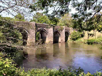
| From Horsebridge, over packhorse bridge (dated 1437) into Cornwall. Permissive path closed, follow road round first bend, L on signed footpath on green lane through edge of Hampt Wood to Lower Hampt. Continue across fields, follow waymarks to Luckett village. Turn R in village, uphill passing Rose Cottage. Turn L at junction along a level road, pass Court House on L. After 100 yards turn R up track for 190 yards to Treoviston Farm. Leave corrugated shed on L, through gate, follow L hedge over stile to metal gate in corner. Head for a wooden fence, slightly R of white building, over wooden stile to wooden gate by Higher Trowes Farm. Across road - FP sign over metal gate, follow right-hand hedge uphill (engine house below you on left). Head for top corner of field, metal gate. Turn R along road past Sunnymead to T junction. Turn R to Stoke Climsland. |
|
For my first section
of the Land's End Trail, in mid May 2007, I decided to do a round walk.
A recent report on our local TV news had shown the Duke and Duchess of
Cornwall at Holmbush Mine at Kelly Bray, a visit connected with Cornwall
and West Devon's new World Mining Heritage
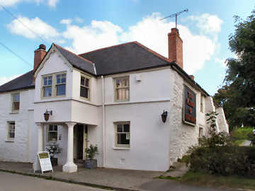
Status. I set off from the Royal Inn in Horsebridge, over the
bridge and round a bend to find the path along Hampt Woods to Lower Hampt
(fascinating manor farm) and on across fields to Luckett. Luckett
was once a busy mining village with a pub and miners institute; those
are gone but the post office - also wine merchant/general stores/diy shop
- is still there. Then by Treoviston Farm, fields and lanes to Stoke
Climsland. The latter is a pleasant village with a church that is
impressive from the outside but of no interest inside. From Stoke
Climsland my round route took me by lanes through Downgate and Holmbush
village to find first an ivy clad engine house down a rough lane to the
right. But my main aim was Holmbush Plantation for the location of
the Duke's visit. Then coffee in the Swingle Tree Inn in Kelly Bray,
at the foor of Kit Hill, before taking more
lanes and a field path back to Luckett to rejoin the trail back to Horsebridge.
You can probably park OK at the Royal Inn at Horsebridge - but ask. |
|
|
Images on and off the trail |
Images of Horsebridge to Stoke Climsland
 |
 |
|
|
|
Stoke Climsland to Linkinhorne - 3½ miles in theory, 4 in practice
| Opposite Stoke Climsland Church take lane (signed ), turns into footpath going downhill to stream. Path goes uphill to Duchy Home Farm; straight on to new building at end of site, go L up ramp and continue W to lane. Turn L along lane past Burraton Cottages. Cross A388 road. Straight on along unclassified road which becomes a track with double bend (R and L) to B3257 road. Turn R to Bray Shop, then first L for 1 mile. 100 yards before lane on L to Treven, through gate in hedge on R, follow hedge on R to gate, follow hedge on L to far hedge then R to gate to road. Turn R for Linkinhorne. |
| My second outing on the Land's End Trail turned out to be a waste of time. It started OK, parking on Stoke Climsland village green, following track, path and lane through Duchy Farm to Burraton Cottages and on to the B3257. There it all went wrong. The lane and private land to Treven doesn't work. So I tried a track to Cockington Farm for a path to Treven and beyond. That doesn't work. So I crossed fields to Trelawney and took lanes and field paths from there to Linkinhorne. I had planned to go further but three hours of aggravation persuaded me to lunch in the Church House Inn (no lunch weekdays) and take the road back to Stoke Climsland. The pub was the day's highlight: pleasant owners, chef daughter, terrific organic granary baguette well filled with bacon and cheese. I hope the next part, to Henwood, is better. |
 |
 |
|
|
|
Linkinhorne to Henwood - 4 miles
| Past Church House Inn to T junction, bear R signed Plushabridge, Rilla Mill to another T junction, turn R for a few yards to sign on L. Cross field to opening. Cross next field, aiming for big isolated tree, through opening, follow lefthand hedge to 5 foot drop, cross stream, through gate. Up field - boggy at first - aiming to L of Patrieda Barton house. Over stone stile and turn L on drive to short green lane on R. Through metal gate, diagonally uphill to hedge, follow hedge on L to road. Cross road, follow hedge on L to road. Turn L on road then road R to Rillaton. Turn R for 50 yards then L to Starabridge. Follow road past Lower Lake Farm; road keeps bending L, along road to North Darley. Cross B3254, up track, take wooden stile to Darley Wood. After wood, cross 2 fields, in 2nd enter woodland to R of rocks. Follow clear path to Henwood. Turn L into village. Then fork R for Sharptor at the tiny green. |
 |
Although I have a
number of comments about the route, this was the first section on which
I was able to follow the trail almost precisely. Gates may have been
different (or missing), and I may have had to avoid crops here and there,
but this June 2007 walk was simple and straightforward. The Church
House Inn in Linkinhorne allowed me to park but wasn't open for lunch so
my return route took me on lanes to Rilla Mill to try the Manor House Inn
there. I was disappointed: my £6 double-decker
mushroom and cheese toastie had a deck of lettuce to cool and dampen the
thin toast, a few chips and a poor salad. But the cafétière
was welcome.
This is an easy section with only a 300 foot height difference. There is a lot of interest along the way: long views to Sharp Tor and Caradon Hill; a nice jumble of farm buildings at Patrieda Barton; charming houses at Rillaton, one with an adapted milk churn for a letterbox; an ancient packhorse bridge at Starabridge. To top it all, strange remains of I know not what in the woods just before Henwood. There are several very tall upright stones, a close-set line of seven fairly tall stones and remains of a structure using some massive granite blocks. I can find nothing about it but would love to know more. It doesn't look like mine remains though one stood nearby. |
|
|
More images along the trail |
Images of Linkinhorne to Henwood
 |
 |
|
|
|
Henwood to Rushyford Gate - 4 miles
| Take R fork to Sharptor village, continue to Wardbrook Farm. Continue, leaving farmhouse on R (beware dogs), through gate onto broad track. Follow fence for over mile. Though metal gate. Bear L, across boggy ground to arched wall on tramway embankment. Over wall, over barbed wire fence, follow tramway to Smallacoombe Woods (permissive access). Through metal and wooden gates. Track very wet for 200 yards. Track continues for mile. Pass open field on R, ignore gate, fork R down track to Rushyford Gate. Through metal gate, cross ford - 2 poles may be needed when stream in spate. |
 |
My fourth sortie on
the Land's End Trail - in June 2007 - would have been very confusing had
I not done almost all of it on two different earlier walks. A lot
has changed since this section was researched in the 1990s. But first
you need to be wary at Wardbrook Farm. Both gates there have 'no
right of way' signs. The one to the right of the farmhouse is almost
certainly the permissive path but, despite the landowner apparently not
wanting walkers, the farmer seems not to mind if you go straight on.
Then the land along the former tramway that you follow for a mile past
the farm has been completely refenced so the original trail instructions
are no longer valid. The set-up at the end of Smallacoombe Woods
has changed, too, so those instructions are now invalid - and, while there,
don't miss Trewortha Medieval Village
in the field on the right (private land).
My own preference at the beginning of this section would be quite different from the researchers. On reaching the road into Henwood, I would turn right for ½ mile and, opposite the first right turning, turn left up a rough track to Bearah Tor, skirt the quarry to the left and follow the tramway and fence to the end of Wardbrook Farm's land before crossing the boggy ground to the tramway to Smallacoombe Woods. This is the way I returned - but then I love the open high moorland. |
|
|
More images on the trail Some Open Access land. |
 |
 |
|
|
|
Rushyford Gate to Bolventor - 4 miles
| After ford half-L, NW uphill. When hill levels out, Halvana Plantation ahead. Metal gate into woods, 208 773. Follow new track to junction, straight ahead to mobile phone mast, bear R out of plantation, through 2 metal gates (probably open) . At end (A30 ahead and below you) turn L and over stile into field. Path clearly waymarked (heading SSW) from here most of way to River Fowey, crossing 4 stiles on to Open Access land E of Carneglos Tor. Continue SSW to stile by 4-bar gate and down to bridge over River Fowey. Cross bridge and up long, rocky, wet green lane. Forward in field to narrow path through Dryworks Farm. Forward to road, R to Bolventor. |
| A straightforward section, despite changes since it was researched. I did an out-and-back, parking at Jamaica Inn. Although straightforward I lost my way completely in Halvana Plantation where tracks have altered. However, the changes made the walk back to Bolventor from Rushyford Gate, simpler. It still surprise me that the trail pays so little attention to what is along the way. When leaving Rushyford Gate I noticed something marked as Rushyford Water on OS109. It turned out to be a former water management system, probably 20th century. Up the hill nearby was an abandoned but nameless farm. A walker I encountered told me he calls it Ivy Hat. By it were remains of ancient long houses, or perhaps primitive barns. While crossing part of East Moor here, you really should detour to see its many antiquities: Nine Stones circle, burial cairns, Altarnun boundary stones, impressive earthworks - and great views from Fox Tor |
 |
 |
|
|
|
Bolventor to St. Breward - 9 miles by map-wheel but I make it 11 on the ground
| From
Jamaica Inn L downhill and under A30. 1st R, 1st L signed Bolventor
Church. 350 yards, over stile on R, over next stile, right of hedge
to bottom. Leave Dairywell Hill Farm on left, uphill on stony lane
to Tolborough Downs (Open Access). Over Tor by cairns and NW ½mile
to fence dividing Catshole and Codda Downs. Continue NNW, sometimes
to L of hedge, sometimes to R, sometimes on top. After 1¼miles
over stile on L, path W to summit of Brown Willy. Follow waymarked
permissive path S and W, cross lane to Fernacre, over stream and stile
onto Butterstor Downs. Ignore boggy waymark path along R fence and
head SW over Butter's Tor. Continue SW to find path again, cross
De Lank River by 2 footbridges and up to Garrow Farm. Follow looping
path SW and W to enter plantation and continue W over stream onto King
Arthur's Downs. W past King Arthur's Hall, follow L hedge to end
of 3rd field. Over stile and SW to Lower (or West) Candra.
Lane up to open moorland. **R to Irish Farm. Waymarked path
continues roughly W to Palmers (some boggy ground) and up to road.
Cross road and follow path to bottom (boggy gateway). Continue W
to reach St. Breward church.
**In wet conditions, better to continue on lane past Penwood Farm and take quiet roads NW to St. Breward. |
 |
Unless sisters Mary or Frances are here I do most of my walking solo. For this section of the trail I was happy to be joined by my neighbour Richard. We parked one car at the Old Inn at St. Breward, drove to Jamaica Inn at Bolventor, parked the other there and, after a coffee, set off on a route I know well from Bodmin Moor walks. The walk directions are fine up onto Tolborough Downs but then get too complicated. Just climb the hill to the left of the Tor and then head north-west for the start of the fence and hedge dividing Codda and Catshole Downs; you need to dodge around from one side of hedge to other (and on top). The 'Nature Conservancy Council' notice is missing but the route up onto Brown Willy obvious - views from there are ravishing. We were delighted to find the well signed permissive path (so its not on OS109) to Garrow but, when we started to climb the fringe of Butterstor, it was boggy along the fence so it is best to climb to the tor and pick up the waymarked path again later. It is then straightforward as far as Irish Farm but was boggy on the way to Palmers and so boggy after that we retraced our steps and used the road to St. Breward Churchtown. The usual excellect hot paninis at the Old Inn. Thanks for good company on the walk, Richard, I look forward to doing more of the trail with you. |
|
|
OS 109. Mostly Open Access land. |
| Antiquities along the way include a massive bronze age burial cairn on the southern height of Brown Willy; an abandoned medieval village on the lane to Fernacre; an abandoned farm below Butterstor; remnants of a stone circle on your left approaching King Arthur's Hall. |
St. Breward to Dunmere - 9 very easy miles
| From St Breward Churchtown follow road S through village and into Ryelands (houses on L, green on R). follow winding lane to to Lower Penquite, along footpath over stiles to Higher Penquite. Turn R along road, then L after 50 yards along old lane, then short stretch of open moor to road, then R to Penvorder Cottages. L along front of cottages, find gate, then across a small playing field, L through ornate iron gate, over granite stile into fields, follow right-hand hedge to wire fence with wooden stile, across this follow fence on L to gate into lane at Lower Lank Farm. Follow lane to road, then S on road to Penpont. At a T junction at ¾ mile, turn R to Camel Trail. L onto Camel Trail, follow trail 6 miles to Dunmere. Borough Arms is up ramp after going under A389 road bridge. |
 |
As with the previous
section I did this one with neighbour Richard. This time, however,
we did not use two cars but enlisted the aid of Jane. She dropped
us off by the Old Inn in St. Breward
and met us later at the Borough Arms at Dunmere, bringing Richard's wife
Jenny so we could all lunch together. The Borough Arms is right on
the
Camel Trail (trail car park beyond
the pub's), serves food all day from noon and is good value for money with
large helpings of everything.
This must surely be the easiest section of the Land's End Trail. Although there is a height difference of 550 feet it is downhill all the way, moderately as far as the Camel Trail and, since it is on the former railway line from De Lank Quarry, very gently from there to Dunmere. Richard and I followed the trail instructions exactly but, looking at OS109, you will see several possible variations on the way to the Camel Trail, including the chance to join the trail at its extremity at Wenford Bridge, where there is a good café. Interest along the way includes some handsome converted barns, most especially at Lower Lank, and the abutments of a bridge at Lower Lank that once carried the quarry railway to join the former Wadebridge to Bodmin line. You may prefer to avoid this section in school vacation time when the Camel Trail can be very busy with cyclists. |
|
|
| Directions
in the Trail guide are very detailed. I have summarised here.
Starts on OS 109, continues on OS 106
Leave Dunmere on the Camel Trail for ¼ mile. Before river fork L through woods to lane. L on lane to Nanstallon. R on road and then immediate L to X-roads. Forward to T, R past Threewaters to X. L for 250 yards then R on bridleway past Higher Mulberry, steeply uphill and downhill to road. R/L to cross road and continue on bridleway to Withielgoose ford on Ruthernbridge-Tremorebridge road. L on road ½ mile to T. R ¼ mile to take 2nd lane on R. Immediately through gate on L and follow unwaymarked path past Whitehay to road. L on road uphill to Withiel. Leave church on L and L into lane, becomes path up and down hill to Lanjew. Through farmyard and continue to road from Tremorebridge to St. Wenn. R past Prince Park and Rostigan to top of hill. Find unmarked path to St. Wenn. L on road for 200 yards then R on unmarked path SW for ½ mile. Cross road to path SW ¾ mile to Tregonetha. |
 |
Another enjoyable
stage of the trail with Richard, approached similarly to St. Breward to
Dunmere but, as there is no pub at Tregonetha, we decided to do this section
in the reverse direction. So Jane left us at Tregonetha and later
brought Jenny to meet us at the Borough Arms at Dunmere for a another alfresco
lunch. I have written this description as if we had just followed
the trail in the correct westerly direction.
Our route seemed clear enough on the map (OS 109 and 106) and, indeed, from Dunmere as far as Withiel and on to Lanjew Farm it is well enough signed. However, perhaps made worse by our doing the walk in the reverse direction, we had considerable problems to the west of Withiel. Here we found almost no footpath signs, had few clear paths to follow (presumably St. Wenn and Tregonetha people don't walk much), and found some stiles quite hidden by bramble, nettles and hawthorn. As a result we missed the route and had to backtrack several times, hence doing 10 miles. We also had to detour to avoid slurry quagmires at several field gates. There are several buildings worth seeing along the route - good churches in Withiel and St. Wenn, an unusual Edwardian house at Prince Park and an attractive converted mill at Withielgoose. |
|
|
Tregonetha to Mitchell - 12 miles but I did more like 14!
| S on road ¼m to L bend. After corner reflectors, R on unsigned path to conifers. R/L track past Castle Farm to Royalton. Forward on track to road. L to T. R to Ruthvoes and on to T. R and shortly L into Treliver. L past buildings and R on muddy track to cross road for road to Black Cross. Forward on lane under A39. Follow road towards White Cross. L on A392 200 yds, R on track, over railway, pass Tresithney, follow path to Barton Lane. L on Barton Lane for ½m. After stream R (unsigned) through boggy pathless woods, crossing stream twice. On leaving woods, cross new farm road (electrified fences) to invisible stile. Cross field (slightly right) to find plank over stream. Negotiate boggy pathless wood (if you can) to find field (no path) leading to road into Troan. Immediately after R bend, go L through gate, path comes out at St. Enoder church. Follow narrow roads by Carvynnick Cottages and Penscawn to cross A30 on A3076 bridge and on into Mitchell. |
 |
After a gap of a couple
of months, back on the Land's End Trail in mid October 2007. Sadly
Richard has had to have an operation so I shall miss his company for a
while. Jane dropped me at Tregonetha and met me 6 hours later at
the Plume of Feathers in Mitchell.
The beginning and the end of this section are straightforward enough (though
with too much road) but the centre section from Barton Lane to Troan
is virtually impossible. The first bit of boggy woodland is bad enough
but in the second bit you need a good compass and good guesswork.
I only found my way through in the reverse direction two days later;
on the walk I had to detour by Retyn Farm. I think it better to follow
Barton Lane almost to Lower Fraddon then take a path past the sewage works
(!) to pick up Narrow Lane to St. Enoder.
The latter part of the walk has little interest (apart from St. Enoder church) but the early part is full of interest: good views up to Castle an Dinas; the amazing house in Castle Caravan Park at Royalton; and a holy well in Ruthvoes. The house, so I was told, was built for an American Ambassador (research reveals nothing); the holy well is dedicated to St. Columba (a female, not the well known Irish Collum Cille, founder of Iona). |
|
|
Mitchell to Zelah - 6 miles (done as 12 miles out and back)
| Unsigned FP S from between Plume of Feathers and Rose Terrace to top. Through kissing gate, cross field to bungalow. Cross road into lane S towards Hendra Farm. At farm turning R into field. LH hedge, track to stream, LH hedge to gate then track to Trewaters bungalow. L on old road to bottom to busy new A39. Cross A39 then R uphill sign Ennis. Follow long lane past Ventonteague Farm to T. L 500 yards, R FP sign, follow LH hedge 2 fields and into Trefronick Farm. R 30 yards, L over stile and follow power lines to stile into lane. R to Trerice. At FP sign L over stile to bottom of third field. R to yellow waymark, cross bridge over R Allen. Up track past Tolgroggon Farm. Bridge over A30 to Zelah. |
 |
The way the trail
is divided in sections, this part should have been Mitchell to Chyverton
Cross, 12 miles according to the route directions but 13 muiles by my calculations.
With no linking buses I decided to split it in two and do Mitchell to Zelah
as an out-and-back. It was a dull early November 2007 Saturday when
I parked at the Plume of Feathers in Mitchell
and set off expecting that this part would work with no problems.
Of course, it didn't happen that way. I think I know where I went
wrong; At the sentence before last, I think I followed a waymark
too soon and found myself having to ford the little River Allen and cross
a bog and a field to find the lane to Tolgroggon.
This was perhaps the least interesting section of the Land's End Trail yet. Apart from Trerice House (no connection with the National Trust's Trerice) and a couple of farm buildings, there was almost nothing to photograph. The images below are the best interest I could find. A 'quiet lane' is Cornwall County council's designation for a multi-use road for cyclists, walkers, riders and local traffic. The stile near Trerice was topped by an intriguing bit of stonework that looked like it was from a church. At least I enjoyed my lunch at the Hawkins Arms in Zelah before returning by a slightly different route. |
|
|
Zelah to Chiverton Cross - 7 miles one way
| Where you join old A30, cross to green lane. At road R then L at X to Little Callestock. L down and up hill to T. L and almost immediately R on track which turns W and passes Chiverton Moor mine. At road L 500 yards down and up. At 3rd field boundary through gate into field. Cross field diagonally, through gap in R hedge and L to metal gate. Through gate and up muddy track to road. R into Callestick and L uphill to Callestick Veor. L S down track past Cornish Cyder Farm (Legless but Smiling) 1¼ miles to road. R then cross road (A3075) to lane which follow W then S to Chiverton Cross. |
 |
This - the second
part of the Mitchell to Chiverton Cross section, done in November 2007
- came as a pleasant surprise after the lack of interest of Mitchell to
Zelah. The sun shone, the countryside looked green and pleasant and
I found a primitive milestone, a standing stone, two lead mines and two
charming villages. A suprise, too, in that, although at Little Callestock
the trail directions were badly wrong (amended above), I found my way without
a single hitch. Jane dropped me in Zelah, enjoyed the beach at Perranporth
and met me at the Chiverton Arms for lunch.
Even before crossing the old A30 to head up the green lane I spotted a primitive milestone (below), then almost immediately I spotted some sort of standing stone in a field on the right. The first village, Little Callestock, was tiny but charming, then I passed mine remains: lead mines at Chiverton Moor (pictured below) and Old Callestick. Then delightful Callestick village: a Georgian house, attractive cottages and a small ice cream business at the farm. At Cornish Cyder Farm I stopped for a coffee and took the photo below. The little church at Chiverton Cross looks distinctly unloved. The pub there, the Chiverton Arms, is unattractive but makes a good bacon sandwich. What a good walk; other than those on Bodmin Moor, the best yet on the trail. |
|
|
Chiverton Cross to Lanner - 7 miles one way, 14 miles out-and-back
| Old A30 towards Blackwater. Pass car sales on L and take lane (public byway) L & R S past Carnhot House to road. L on bridge over A30 and R to continue on byway. At road forward, over railway bridge and continue to junction with phone box. L 50 yds and R following Mineral Tramway Devoran arrows. Pass Hawke's Shaft engine house and into Unity Wood. Where path divides fork R to bottom and out of wood. [1] R on path (parallel to road) to Killifreth Farm lane. Cross B3298 to muddy green lane (becomes tarmac) dividing Scorrier House estate. At T turn R up and down through Vogue. R, pass Star Inn, take R fork to Busveal. L past Gwennap Pit ¼ mile, R up track. ½ mile up track S to second cross track. W uphill to pool in quarry at top of Carn Marth, bear L downhill to A393 at N end of Lanner. Cross busy A393 and continue ¼ mile to covered reservoir dome. Route continues R on track W from small car park area. |
 |
[1]
I have made a change here. Trail turned L to do 500 yards on B3298,
a busy dangerous road. Now there is a new mineral tramway path off-road,
I have amended the route. I have also reworded other instructions.
This section is really Chiverton Cross to Beacon but, with no buses 12 miles each way would have been too far, so I parked just down the public byway and walked to Lanner reservoir and back. I particularly enjoyed this section as it brought me back to familiar mining country and along some Mineral Tramway trails as well as up a favourite hill, Carn Marth. The route begins along a pleasant green lane (public byway), picks up the Wheal Busy Loop of the Coast-to-Coast Mineral Tramway through Wheal Busy Downs and down through Unity Wood. My route then passes a standing stone by Killifreth Farm before taking a lane dividing the Scorrier House estate - some charming estate buildings here. After Vogue you pass Mynheer Farm where you can ask to see the Roman milestone. Do then stop off to see Gwennap Pit before heading up Carn Marth. On the way back I stopped for an incredibly good value light lunch at the Star Inn at Vogue, an ordinary 'local' with charming hosts. |
|
|
Lanner Reservoir to Beacon - 5 miles, 9 as a round walk
| Parking at Lanner Reservoir. W on firm track. At converted chapel, X road and forward following Great Flat Lode trail markers. Pass paddocks and Wheal Bassett Stamps. [1] At tarmac lane, R down into Carnkie. L in village and first R on lane to top of Carn Brea. L past Bassett Monument and follow path W then WSW downhill. At tarmac lane, cross and pass [2] back of cottage on to narrow green lane down to bottom. Go through [3] LH cottage garden to road. R on road 75 yards. L then over stile. Follow LH hedge. Over stile on to lane past smallholding. R on road down to Brea Adit. X busy road and up steep tarmac track following Great Flat Lode signs. R at road and R again into Beacon village. |
 |
Again,
things have changed, thanks to Great Flat Lode trail signage.
This walk, done with my siater Mary in November 2007, was a delight. It took us through mining country, partly on the Great Flat Lode trail, a great favourite for all its mine sites. A delight, too, that we made a round walk of it so that we could lunch at the always excellent Countryman at Piece and pass through South Wheal Frances. Generally this walk is quite straightforward with just three points of doubt. [1] Here you turn into Carnkie later than the LET route. [2] It looks as if you are going through a garden, you are not. [3] Here the path does go through a garden. We parked at Lanner Reservoir and enjoyed the level walk to Carnkie. There is an easy climb up Carn Brea. At the top linger to see Carn Brea Castle, hut circles, the Bassett Monument, massive rocks and views of St. Ives. The climb up from Brea Adit is the only tough part; there is even a sign at the top 'Steep hill riders dismount'. No refreshments in Beacon, hence our return detour to the Countryman with the added bonus of then passing through South Wheal Frances, a surprisingly well preserved mine site. All in all, this was one of the best and easiest of all my Land's End Trail walks so far. |
|
|
Beacon to Clowance - 6 miles (10 as a round walk)
| The
LET route directions are long and detailed. I have summarised.
Parking opposite the Beacon Inn. Cross road to Tolcarne Road. S on track to pass Woodview cottage. R down narrow holloway to woods. Cross stream and uphill RH hedge of two fields. Stile over hedge and forward to road. R/L on road into Treslothan. At well on L corner, L past cottage and continue S along and through woods to road. R on road downhill to Carwydden. L before bridge on track to Bodrivial. Pass Bodrivial to L, and R at end on path which (if you can find it) leads SW and S to road. L on road to pass Carn Trmayne then R over 8 or 9 stiles to B3280. X road for clear path to Crowan. Pass church and take clear lane and path across fields to B3303. Cross road and enter Clowance estate on byway W |
 |
With the aid of my
map wheel I had calculated that it was 7 miles to Leedstown. Setting
off early from Beacon, I had expected to make the Duke of Leeds in Leedstown
for lunch before a 6 mile return mostly on lanes. I had reckoned
without the twin curses of the Land's End Trail - unfollowable paths and
unpassable mud and slurry filled tracks. In the event it took me
3 hours to get as far as Clowance House, at which point I decided to wander
around the estate (now a time share) and lunch in the St. Aubyns Arms in
Praze-an-Beeble.
Everything went fine until I got to Bodrivial (or Bodryvyal). Soon after I found myself on what the County Council, in its wisdom, signs as an 'improved path'. The track was filled with mud and slurry, the sides were thick with furze and brambles. It must have taken ne nearly half-an-hour to cover 100 yards. Then an ummarked path petered out and I wandered through fields, finally finding my way on to the road at Trethannas. All plain sailing from there. To be fair, some of my lost time was occupied with exploring fascinating Treslothan (once the Pendarves estate village) and enjoying the memorials inside Crowan church. Clowance looks like an interesting time share. The St. Aubyns Arms is a drab pub but the welcome and food were good. |
|
|
Clowance to Leedstown - 3 miles (9 miles as a round walk)
| Again
the trail directions are not strictly accurate. These are amended
directions. The official trail directions do not actually take you
into Leedstown. Since there is a pub at the crossroads there, the
Duke of Leeds, I have taken my directions to the pub.
[1] From front of Clowance House, pass (on L) lake and childrens play area. Bear L following chevron FP sign, over stile into field. Follow RH hedge into 2nd field. Cross field diagonally and through gate. [2] L on track then bear R on track into woodland. Keep to R edge of woodland. Through gate and bear R to join muddy track to road at Clowance Wood Farm. Through gate to R of farm and cross 2 stiles to lane. R on lane and shortly L onto track, becomes road. At R bend, go forward on narrow bridleway to road. R on road to Praze-Leedstown road. L to centre of Leedstown. |
 |
[1]
I did this in early December after heavy rain. In these circumstances
the track before Clowance Wood Farm is almost impassable. I recommend
at [2] forward on track to Bold Gate exit.
L on road towards Leedstown. Ist L on road to Clowance Wood Farm.
As I had only 3 miles left to Leedstown, I decided to make a round walk of it, parking in the lay-by opposite Leedstown C of E school on the Goldsithney road. I continued on the road downhill then turned L to Polglase Farm, over a stile before the farm onto a track to the B3223. There I crossed and followed the small road to Fern Farm where I turned L through Horsedowns on lane, track and through fields to Clowance Wood Farm. There, now on the LET in reverse direction, I waded through the deep muddy track following the LET to the second patch of woodland. There I turned SW on a track though the edge of Fox Grove wood to the road. I then took the road to Praze for another lunch at the St. Aubyns Arms. After lunch I followed the Leedstown road to Bold Gate, checked the byway towards Clowance House, returned to the Leedstown road and took the first left to Clowance Wood Farm. From there I followed the trail (above) back to Leedstown. An uninteresting section of LET. |
|
|
Leedstown to St. Erth - 7 miles
| Park in layby opp CE primary school (where official trail crosses B3280. Take byway NW and SW past Carsize Farm. Before next R bend, L through gate and take L fork. SSW across field and bear R up green lane and through gate. [1] SSW across field to headland, continue SW to steps down to road. Cross road and SW to 'Private' sign. Detour R and L to skirt house then continue SW to Kerthen Wood Farm. Cross lane and continue SW and NW to road at Bosworgy. L on road, R at T, cross stream. L on path to Trannack Farm. Over stile and down narrow gap into farmyard. Pass wooden barn and bear L & R on muddy track to Trannack Mill. Pass house and continue to bridge over River Hayle. Turn R and follow river along broad bridleway to St. Erth bridge. |
 |
In a period of very
wet early December 2007 weather I had to pick my day carefully for this
one. In the event the weather was quite kind to me:
a fair amount of sun - though that hadn't dried out paths and tracks which
were very muddy - and one bout of rain, one of horizontal hail and winds
gusting to 40 knots. This time I found the LET trail directions clear
enough. The only problem I encountered was at [1]
where
the field has been ploughed and you may need, as did I, to skirt the field
following the left-hand hedge.
This was, apart from the muddy conditions, a very easy walk and almost completely level. There were some good farm buildings along the way, many of the barns converted as holiday homes or holiday rentals. The farmer at Trannack Farm was helpful in pointing me the right way where the path was difficult to spot. The owner at Trannack Mill was less helpful; she was quite offended that I should want to photograph her ruined mill building. From Trennack Mill I was delighted that the path (a bridleway) followed the River Hayle all the way to St. Erth. St Erth church was a delight, too, but I was disappointed to find no food at the Star Inn there. Needing to make time, I used the road back to Leedstown - 5 miles in 70 minutes with a 40 knot tailwind. |
|
|
St. Erth to Trencrom Hill and St. Michael's Mount - 9 miles
| Cross bridge, past toilets to path on L by white house, across 2 fields to Tredrea Manor. Turn L and track bends R, joins metalled road. To T junction, turn R. At next T junction, turn R and L onto footpath, cross lane to wider track, into field bearing L to railway crossing. Up lane, through Polgrean Farm to A30. Turn L to former Whitecross School, then R up lane to Collorian, then straight on to CP at foot of Trencom Hill. Climb Trencrom Hill for views. Return to CP, R on road and follow St. Michael's Way to Marazion and St. Michael's Mount. |
 |
In theory the Land's End Trail finishes at Trencrom Hill to be followed by a linear walk to St. Michael's Mount and then by the Penwith Round. I chose to put two sections together and to walk from St. Erth to the Mount by way of Trencrom Hill. I chose a glorious December 2007 day for it and enjoyed a fairly easy 9 mile walk with superb views from Trencrom Hill. And, to my delight, for the first time I was able to make use of a bus. I parked (free) in Marazion, caught the Western Greyhound 515 to St. Erth and was walking at 10.30. The trail directions are straightforward from St. Erth to Trencrom Hill and are unnecessary from there to the Mount as all you have to do is follow the clear waymarking of St. Michael's Way. There are a lot of stiles along the way, some of the granite Cornish stiules poorly maintained, some replaced by wooden stiles and even one hybrid. For me the highlight was the wonderful views from the iron age fort on the top of Trencrom Hill: west to Rogers Tower, north-west to Trink and Rosewall hills, north-east to St. Ives Bay, east to the Hayle estuary, south-east toTregonning Hill and Godolphin Hill, and south to St. Michael's Mount. A wonderful panorama. Below you will find my conclusions about the trail and some advance information about the trail in reverse. |
|
|
My conclusions & the Trail in Reverse |
The Land's End Trail - My Conclusions
| It has been a difficult trail for me to complete, for several reasons. First, doing it in bits, there has only been one part where I have been able to use a bus to make it a simple linear walk, although on the three sections from Bolventor to Tregonetha my friend Richard was able to join me to provide a second car; otherwise it has been round walks or out-and-backs. Next, the directions have in a few cases proved impracticable through right-of-way changes. Finally, there have been some parts so muddy in winter as to be almost impassable and others where only a compass direction will find where the path continues. I don't want that to read as if I haven't enjoyed the trail. I have; its 110 miles (that's what I reckon I did from Horsebridge to St. Michael's Mount) have proved challenging and mostly enjoyable with quite a variety of landscape along the way. For me the highlights have been the crossing of Bodmin Moor from Henwood to Dunmere, mining country from Zelah to Leedstown, and the final section for the wonderful views from Trencrom Hill. Having got as far as St. Michael's Mount, I now plan to do the Penwith Round which will take me from the Mount to Cape Cornwall and back to Penzance. And now I discover that the trail has now been researched in reverse - but starting at Land's End. So maybe that will follow. | |
| The Trail in Reverse |
|
The Land's End Trail - West to East
 |
No sooner had I
completed the Land's End Trail from Horsebridge on the River Tamar to St.
Michael's Mount in West Penwith than I learned that those who had devised
it had now revised it. The revision is planned to be the south-western
end of what it is hoped will be a Land's End to John o'Groats national
trail. The full Land's End Trail, of course, continues from the Devon
border as far as Avebury in Wiltshire. My concern, however, is only
with the Cornish part, of which I have been privileged to see a draft.
The west to east Trail differs in some places from the original east to west one though the changes are largely only at the extremities. I am especially pleased to see that it now starts at Land's End (much as I hate the awful commercial aspects of it). So Stage 1 is entirely new and most of Stage 2 is new too. I shall enjoy taking the high ground most of the way to St. Erth. At the eastern extremity I am delighted that it now takes in the Minions area, Caradon Hill and Kit Hill, three of my favourites spots. My next walking project is the Penwith Round (St. Michael's Mount to Cape Cornwall and back to Penzance). Then I hope to tackle the new LET during the drier weather of 2008. I disagreed with parts of the original route. We shall see what I think when I come to these parts in reverse in 2008. |
|
|
|
|
|
|
|
|
|
|
|
|
|
|
|
|
|
|
|
|
|
|
|
|