

| Oliver's Cornwall |
|
around Bodmin Moor |
| The
Copper Trail was devised
and researched by Mark Camp. The full trail guide is available
from
good local bookshops. You can also order it, and find information
on Mark's excellent Bodmin Moor guides, and much more, on the
interesting Best of Bodmin Moor web site. (2020: Site seems to have disappeared). |
|
|
|
|
|
|
|
|
Text and images should align.
To view this page at its best, adjust your zoom so that the page uses full
screen width
ON THIS PAGE
|
|
|
|
|
CORNWALL REVIEWS INDEX and SITE CONTENTS
|
|
|
|
|
|
|
|
|
|
|
|
|
|
|
|
|
|
|
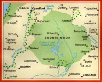
The Copper Trail - a circular trail round Bodmin Moor
 |
Mark Camp is known as an authority on Bodmin Moor. In 2005, he excelled himself with a continuous 60 mile trail around the moor, which he calls the Copper Trail, appropriately since Minions and Caradon Hill were once the centre of a great copper mining boom. The Trail begins at Minions village and goes by way of St. Neot, Bodmin, St. Breward, Camelford, Five Lanes (near Altarnun) and back to Minions. After completing the Cornish Coast Path, this was my next project. But, unlike Mark's continuous route, I did it in a series of short out-and-backs or circulars. In winter 2006 it proved very wet and muddy - but none the worse for that - with an enormous amount of interest, with high moorland (I love it), remote farms, ancient monuments, clapper bridges, Cornish crosses, boundary stones and mine ruins along the way. Thanks to Mark, I have now devised and enjoyed many of my own walks on the moor. Recommended pubs along the trail are the Crows Nest, the London Inn at St. Neot and the Old Inn at St. Breward. I have had many good lunches at all these and also enjoyed the King's Head at Five Lanes and Racehorse at North Hill. For a description of the route you can't better Mark's booklet; I have just added below a selection of photos taken along the way, some on-trail, some off - and a few comments. It's all on Ordnance Survey Explorer sheet 109. |
|
|
Images
of the Copper Trail |
| In each description
I have included, where I have it, information on where I parked, possibilities for pub lunches
and links to interest along the way. The Official Copper Trail Web Site has gone missing but look at Visit Cornwall's Copper Trail page |
Online Mapping - Cornwall Council Mapping Website
 |
The recently introduced 'Right to Roam' legislation - long agitated for by the Ramblers Association, and initially opposed by many landowners - has resulted in vast areas of land all over England, Scotland, Wales and Cornwall being opened up to the general public. Essentially these rights are for walkers only - suits me. I used to find the Countryside Agency's Open Access website an immense help in my Cornwall moorland walking, not just on Bodmin Moor but also in West Penwith. Unfortunately the site, now Natural England, has been messed around with and although the maximum scale is acceptable, maps are too small and navigation is quite awkward. As a result, it is no longer worth, as a walker, using it in its current CRoW Access form. Fortunately, Cornwall Council has an excellent mapping web site, which I find better than the Open Access site ever was. It is easy to use, shows Open Access land, rights of way, path numbers should you wish to report problems, and is zoomable up to large scale. A word of warning on Open Access land.. I soon discovered that this may not be quite as straightforward as that. I have encountered barbed wire fences, locked gates and even one gate on Bodmin Moor, leading to access land, that has a 'no walkers' sign on it. And, in West Penwith, where moorland is lower, I have found impenetrable furze and bramble. So don't expect it to be easy. |
|
|
OS Explorer maps show Open Access land as yellow |
Ordnance Survey Maps - 1:25000 Landranger Series
 |
My earliest walking
was done with Jane with the Independent Ramblers, based in Ealing.
With them we learned to love the Chilterns and the Cotswolds. But
we soon graduated to our own independent walks, first from walk books,
later of our own devising. The Ordnance Survey 1:25000 series
became our bible. The current 2005 Explorer series still is my bible
(to a degree) particularly as it now shows Open Access land. But,
as with the Bible, you learn not to believe every word. I use OS
maps, GPS and compass on most walks, especially on Bodmin Moor and on the
moors of West Penwith. But I have lost some trust in OS.
Since completing Mark Camp's Copper Trail during winter 2006, I have been walking routes of my own devising on Bodmin Moor and have been horrified to discover just how unreliable the Ordnance Survey can be. A couple of walks in December 2006 proved that. A path shown from Butterstor to Garrow simply does not exist yet OS quite fails to show a well waymarked path from Brown Willy to Garrow (and on to King Arthur's Hall). Below Garrow the OS fails to mark a footbridge over the De Lank River. It also fails to show a footbridge and clapper bridge that cross the river at the southern foot of Garrow Tor. Elsewhere I have found marsh that isn't shown, probably because it is not low-lying. So be advised, take your map, take your compass and expect the unexpected. |
|
|
Don't expect all antiquities to be marked either |
Images of the Copper Trail (index below or just scroll down)
| Mark Camp's Copper Trail walk book assumes (I think) that you will walk the trail in one expedition, staying overnight in towns and villages along the way. He has, therefore, divided its 60 miles into 6 sections, starting in Minions, so that you can stay overnight in St. Neot, Bodmin, St. Breward, Camelford and Five Lanes or Altarnun. Living in Cornwall, I chose not to do this but to divide each of the Trail's sections into 2 out-and-backs or round walks; in one case - St. Neot to Bodmin - I split it in 4, in another - St. Breward to Camelford - I did the whole section one way. In case you decide to walk the trail my way, you will find that I have mentioned where I parked for each walk. |
Minions to Draynes
Bridge - Mineral tramways, copper mines, antiquities
This is
the first half of the Trail's Minions to St. Neot section
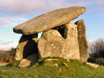
| For my first outing on the Copper Trail I decided to do a round walk. I parked in the free Golitha Falls car park at Draynes Bridge and followed my own route on footpaths, across the foot of Bulland Moor and by Commom Moor and Great Gimble to the Open Access land that leads to Minions. From there I took Mark's Copper Trail route back to Draynes Bridge. I don't expect to find a more interesting section of trail than this: a mineral tramway, mine remains, Trethevy Quoit, St. Cleer Holy Well and King Doniert's Stones all in one walk. And, as bonuses, a short walk to Golitha Falls and lunch along the trail at the excellent Crow's Nest Inn, south of Minions. A Bodmin Moor Round Walk, starting from Minions, takes in most of these features. |
 |
 |
|
|
|
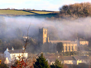
Draynes Bridge
to St. Neot - woods, high moors, charming St. Neot village
This is
the second half of the Trail's Minions to St. Neot section
| Once again I parked at Draynes Bridge but this time I immediately followed the Copper Trail to St. Neot, then made my own way back to the car. This time there was more road than I might have liked on the trail (impossible to avoid) but I was delighted with Berry Down and its iron age hill fort. After a good lunch at the London Inn in charming St. Neot - and a brief detour for the holy well - I took a more northerly route back, using part of the Two Valleys Walk (OS109) but leaving it at Higher Bowden to take a farm track to Carpuan and field paths to West Draynes. More road than I would have liked en-route. |
 |
 |
|
|
|
St. Neot
to Colliford Lake - open moorland and a vast reservoir
This is
the first of four parts of the Trail's St. Neot to Bodmin section
| Unlike the previous two Trail sections, which I split into two out-and-backs or round walks, this one, which is 13 miles from St. Neot to Bodmin, I split into four. At the time he researched to Trail, Mark was unsure about crossing Penkestle Moor. I did, with no problems, and it is now Open Access land and well worth crossing. I was only able to make a small variation for my return leg, heading a little further west to take in Penkestle Farm and Trevina. As my walk was a short one, I had time for lunch at the London Inn and to explore St. Neot village. No problem with parking, thanks to the free car park in St. Neot. |
|
|
 |
|
|
|
Colliford Lake
to Mount - high moorland, ancient burials, remote farms
This is
the second part of four of the Trail's St. Neot to Bodmin section
| Although the Trail uses a fair bit of road on the way from Colliford Lake (ample parking) to Mount, the roads are quiet and straightish and no problem. I varied a little from the Trail because I could not resist climbing Carburrow Tor; I was glad I did for both the prehistoric burial cairns on top and the views. Along the way there were some interesting old farms, a very shaggy pony and the remnants of Wheal Whisper. For variation, my return route took me from Pantersbridge, along a byway in the valley of the little Warleggan River and steeply up to Warleggan village where I enjoyed the church (some time later, Jane and I visited the open gardens there). Then I crossed Warleggan Moor and, level with Carburrow Tor, took a field path through Mennabroom. Bodmin Moor Round Walk includes Colliford Lake, Warleggan, Carburrow Tor. |
 |
 |
|
|
|
Mount to Ladyvale
Bridge - inscribed stones, more farms, coniferous forest
This is
the third part of four of the Trail's St. Neot to Bodmin section
| I did this part as a round walk, parking by the village hall in Mount. On my outward walk on the Trail I saw the inscribed stones near Welltown Farm, enjoyed the gate to Castle Farm on the edge of Cardinham (shame you can't access the Norman motte and bailey there) and ended at Ladyvale clapper bridge. In Cardinham Woods (Hurststock Wood at this point) I took Mark's suggestion of a detour to see the remains of Wheal Glyn Mine. I took a more northerly route on my return, leaving the Trail at Milltown Farm in order to explore Cardinham village (an interesting place) and its church. From there I went to find Treslea Cross, an impressive one, and crossed Treslea Down. On both outward and return journeys I came across several of the delightful ancient direction signs that you find in these parts. |
 |
 |
|
|
|
Ladyvale Bridge to Camel Trail - clapper bridges,
more forest, old barns
This is
the fourth part of four of the Trail's St. Neot to Bodmin section
| This time Jane drove me to the Cardinham Woods car park and walked with me as far as Ladyvale Bridge. While I walked the Trail she went shopping. When the Trail reaches the Camel Trail in East Wood, it turns north towards Blisland. I turned south to Dunmere and met Jane there. We would have lunched in the Borough Arms but it was so busy that we went on to the tearoom at Pencarrow. I found this perhaps the least interesting section of the Trail. For a start, coniferous woods are not to my taste. And, to be going on with, there was little of the antiquarian interest found elsewhere. There were, however, a couple of interesting farms, notably the barn with tallet steps at Copshorn. |
| Update 2014: There are now several dedicated cycle trails in Cardinham Woods, so be a liitle careful when walking through. You will find an item on Cardnham Woods on my Countryside Pages and you can download a leaflet from the Forestry Commission's web site. |
 |
 |
| Ladyvale Clapper Bridge | In Cardinham Woods |
Camel
Trail to Blisland - former quarry railroad and lovely Blisland village
This is
the first part of two of the Trail's Bodmin to St. Breward section
| This is very familiar territory. The route is completely obvious and I had walked it many times previously. The first time I did was with Jane and Mary; we left a handbag in the Blisland Inn and had to traipse all the way back up the long hill from the Camel Trail. As then, this time I did it as a simple out-and-back, parking at the Borough Arms at Dunmere, having coffee at the Blisland Inn and a late lunch at the Borough Arms. The only real interest along the way is the delightful woodland at Shell Woods and, at the end, the charming village of Blisland. |
 |
 |
|
|
|
Blisland to
St. Breward - a boggy bottom, a granite quarry, a long village
This is
the second part of two of the the Trail's Bodmin to St. Breward section
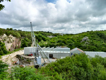
| Surprisingly, I had not previously walked between Blisland and St. Breward; since this occasion I have done so several times. On this occasion my sister Mary, on holiday with us, joined me. Once again we did this part as a simple out-and-back, parking on the green in Blisland. Interest along the way, apart from pretty countryside and some long views, is mainly industrial: the former De Lank quarry hydro-electric plant by the De Lank River and the De Lank granite quarry itself up the hill from there; the hydro plant was then largely hidden by undergrowth but was restored in 2011. You probably won't be surprised that we lunched at one of my favourite pubs, the Old Inn in St. Breward. |
 |
 |
|
|
|
St. Breward
to Camelford - a very wet day, china clay and muddy farms
This is
the complete St. Breward to Camelford Section of the Trail
| I had some pretty wet walks on the Copper Trail; this was the second wettest after the final walk finishing at Minions. Unusually, I chose to do this part in reverse. There was method in my madness: Jane dropped me in Camelford and later met me in St. Breward for lunch in the Old Inn. As you can see, it was another rather wet day but the largely lowland walk was still enjoyable. No especial interest on the way although there is quite a good view of Stannon China Clay pit with Roughtor behind and an impressive clapper bridge that carries a minor road into Camelford. If you look at OS Explorer 109, you will see several alternatives to the official Copper Trail route. And see my Camelford - St. Breward Round Walk |
 |
 |
|
|
|
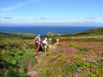
Camelford to
Sancreed Cross - surprisingly level, wartime airfield, conifers
This is
the first part of two of the Trail's Camelford to Five Lanes section
| This part I did as an out-and-back from Camelford, where parking is free. Walking is almost all on lanes and is level apart from the initial climb out of Camelford, heading towards, but not reaching, Roughtor. There is relatively little interest along the way, except for some wartime earthworks on the old Davidstow airfield, the farm at Oldpark and a Cornish cross head at the road junction by Sancreed and New Park farms. When I got back to Davidstow airfield, I decided to cut through Davidstow Forest - conifers and runways. |
 |
 |
|
|
|
Sancreed Cross
to Five Lanes - fine barns, clapper bridge, manorial village
This is
the second part of two of the Trail's Camelford to Five Lanes section
| Despite the fact that it is nearly all on roads (quiet) I particularly enjoyed this section, which I did as an out-and-back from Sancreed Cross, parking just down the lane to Bowithick from New Park Farm. I am particularly fond of Bowithick village (really just a hamlet) with its handsome barns, ford, clapper bridge and tramway remains. And I have enjoyed terrific walks starting from there and taking in five hills on one of the most isolated feeling parts of Bodmin Moor. Further on the Trail departs from the road at West Carne, with its attractive manorial grouping, to cross fields to South Carne, passing on the way a strange small barn, enclosed by a high hedge. Before returning to Sancreed Cross I visited the John Wesley museum in Trewint, lunched at the King's Head in Five Lanes and made Mark's suggested detour to Altarnun. |
|
|
 |
|
|
|
Five Lanes
to Trebartha - long views north, timber yards and superb barns
This is
the first part of two of the Trail's final Five Lanes to Minions section
| I found this one of the most interesting
parts of the Trail, not least for what I learned along the way. I
parked in a layby at Five Lanes and again did it as an out-and back but
with an added bit to get lunch and a variation on the return leg.
I was fascinated by the roughly thatched building at Trenilk, identified
by Mark as a former butter store. I wondered about the farm at Clitters:
a (probably) 19th century house, intact but empty and with no road access;
behind it an earlier abandoned house; in front of it small
enclosures of an even earlier farm. I enjoyed the hamlet of Stonaford,
mine remains at Treburland and handsome farm buildings elsewhere.
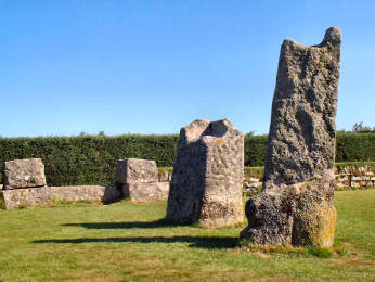
Near Clitters the Trail directed me to an Altarnun boundary stone, my first
introduction to these. I was so fascinated that, on the return leg,
I left the Trail at Clitters and headed up East
Moor to find more boundary stones and Nine
Stones circle. Then over Fox Tor to return to Five Lanes
by a lane down to Tregirls. My lunch detour was to try the Racehorse
Inn at North Hill, an enjoyable break. I also particularly enjoyed
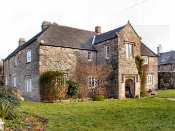
Trebartha,
a fascinating and solidly built estate village. The original Trebartha
Hall was replaced by a modern house but, in 2007, Jane and I enjoyed its
landscape
garden. |
 |
 |
|
|
|
Trebartha -
a prosperous looking estate village, even in the rain
Trebartha
House's attractive landscape garden,
opens occasionally in summer
 |
 |
|
|
|
Trebartha
to Minions - heavy rain, quarries, mines - photos taken earlier
Second leg of the final part of the Trail's Five Lanes to Minions section
| This was probably the wettest day of many wet days on the Trail. I knew there were long views to Dartmoor to the east but I never saw them. The day was quite unphotographable so the images below are those taken in the area on an earlier occasion. This was also only the second time I had set out in the wrong direction. I parked in Minions and did a straight out-and-back to Trebartha but with a detour for another lunch at the Racehorse Inn. I notice that, in Mark's Trail directions, he considers the possibility of taking a hill route from East Castick to Minions but rejects it because of doubts over legal access to Twelve Men's Moor, Kilmar Tor, Bearah Tor and Langstone Downs. Since Mark's research (and what a job he had to do) all this land is now Open Access so, if you love the high moorland, this might be your preferred route to Minions. |
 |
|
|
|
|
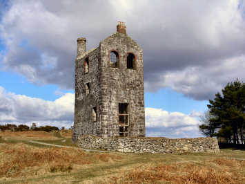
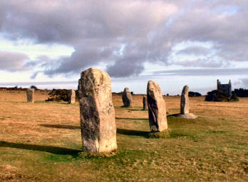
Minions - start and finish of the trail - mine relics and prehistoric sites
| Minions has been the starting point of many subsequent superb Bodmin Moor walks, including a great Three Tors Walk and another taking in Stowe's Hill and Caradon Hill. It is not, in itself, much of a village - post office and village stores, a decent tearoom, a couple of rows of attractive cottages, and a pub I think little of - but, if you are after antiquities, this is the place to come. There is ample free car parking at each end of the village and short walks will take you to fascinating antiquities at the Hurlers and Pipers, Stowe's Hill, the Longstone Cross and King Doniert's Stones. Mine enthusiasts will find a visitor centre in a former engine house and moderate walks will take you to Prince of Wales Mine and to South Caradon mine, the latter along a former mineral tramway. For a choice of several walks from Minions see my Bodmin Moor Walks page. |
 |
 |
|
|
|
|
|
|
|
|
|
|
|
|
|
|
|
|
|
|
|
|
|
|
|
|